|
|
|||||||||||||||||
| Point ID: 9419 | Downloads | Plots | Site Data | Code: 15635000 |
|
|
|||||||||||||||||
| Download | |
|---|---|
| Site Descriptor Information | Site Time Series Data |
| Link to all available data | |
| View: | Time Series | All |
| Units: | mm |
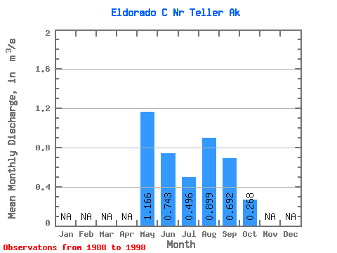
| Statistic | Jan | Feb | Mar | Apr | May | Jun | Jul | Aug | Sep | Oct | Nov | Dec | Annual |
|---|---|---|---|---|---|---|---|---|---|---|---|---|---|
| Mean | 1.17 | 0.74 | 0.50 | 0.90 | 0.69 | 0.27 | |||||||
| Standard Deviation | 0.72 | 0.73 | 0.28 | 0.64 | 0.27 | 0.20 | |||||||
| Min | 0.56 | 0.17 | 0.23 | 0.24 | 0.19 | 0.13 | |||||||
| Max | 2.60 | 2.44 | 1.12 | 2.45 | 1.00 | 0.41 | |||||||
| Coefficient of Variation | 0.61 | 0.98 | 0.57 | 0.71 | 0.38 | 0.73 |
 Return to R-Arctic Net Home Page