|
|
|||||||||||||||||
| Point ID: 9419 | Downloads | Plots | Site Data | Code: 15635000 |
|
|
|||||||||||||||||
| Download | |
|---|---|
| Site Descriptor Information | Site Time Series Data |
| Link to all available data | |
|
|
| View: | Statistics | Time Series |
| Units: | m3/s |
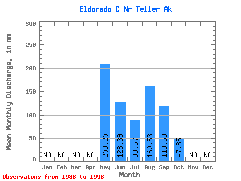
| Statistic | Jan | Feb | Mar | Apr | May | Jun | Jul | Aug | Sep | Oct | Nov | Dec | Annual |
|---|---|---|---|---|---|---|---|---|---|---|---|---|---|
| Mean | 208.23 | 128.37 | 88.57 | 160.54 | 119.65 | 47.82 | |||||||
| Standard Deviation | 128.01 | 125.59 | 50.15 | 113.49 | 45.74 | 34.80 | |||||||
| Min | 100.47 | 29.77 | 41.42 | 42.49 | 33.08 | 23.21 | |||||||
| Max | 465.08 | 421.30 | 200.31 | 437.88 | 172.57 | 72.42 | |||||||
| Coefficient of Variation | 0.61 | 0.98 | 0.57 | 0.71 | 0.38 | 0.73 |
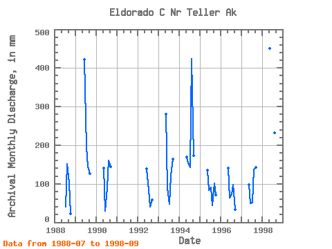
| Year | Jan | Feb | Mar | Apr | May | Jun | Jul | Aug | Sep | Oct | Nov | Dec | Annual | 1988 | 41.42 | 156.74 | 103.40 | 23.21 | 1989 | 421.30 | 200.31 | 149.72 | 125.92 | 1990 | 144.43 | 29.77 | 92.30 | 166.18 | 145.16 | 1992 | 138.59 | 85.70 | 42.49 | 58.04 | 1993 | 289.88 | 88.55 | 49.45 | 125.83 | 163.59 | 1994 | 174.06 | 153.50 | 146.58 | 437.88 | 172.57 | 1995 | 139.27 | 82.76 | 92.66 | 44.63 | 101.13 | 72.42 | 1996 | 144.45 | 62.64 | 74.98 | 100.82 | 33.08 | 1997 | 100.47 | 49.84 | 53.02 | 141.06 | 142.40 | 1998 | 465.08 | 49.27 | 240.06 | 151.19 |
|---|
 Return to R-Arctic Net Home Page