|
|
|||||||||||||||||
| Point ID: 9378 | Downloads | Plots | Site Data | Code: 15300000 |
|
|
|||||||||||||||||
| Download | |
|---|---|
| Site Descriptor Information | Site Time Series Data |
| Link to all available data | |
| View: | Time Series | All |
| Units: | m3/s |
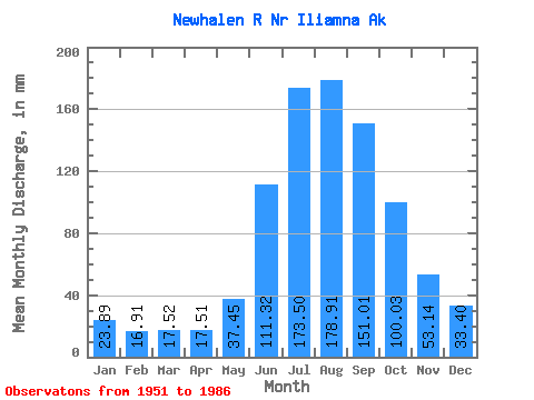
| Statistic | Jan | Feb | Mar | Apr | May | Jun | Jul | Aug | Sep | Oct | Nov | Dec | Annual |
|---|---|---|---|---|---|---|---|---|---|---|---|---|---|
| Mean | 23.89 | 17.06 | 17.52 | 17.50 | 37.45 | 111.32 | 173.48 | 178.88 | 151.00 | 100.02 | 53.14 | 33.40 | 905.11 |
| Standard Deviation | 7.23 | 5.11 | 5.00 | 5.37 | 9.99 | 24.82 | 26.52 | 26.64 | 32.40 | 29.52 | 16.25 | 10.92 | 94.47 |
| Min | 10.10 | 7.67 | 8.42 | 9.78 | 20.61 | 66.23 | 135.07 | 133.66 | 78.10 | 60.16 | 27.70 | 15.15 | 769.76 |
| Max | 38.67 | 27.06 | 28.05 | 26.66 | 53.68 | 160.95 | 218.39 | 251.52 | 207.23 | 167.55 | 88.83 | 53.94 | 1078.74 |
| Coefficient of Variation | 0.30 | 0.30 | 0.28 | 0.31 | 0.27 | 0.22 | 0.15 | 0.15 | 0.21 | 0.29 | 0.31 | 0.33 | 0.10 |
 Return to R-Arctic Net Home Page