|
|
|||||||||||||||||
| Point ID: 9378 | Downloads | Plots | Site Data | Code: 15300000 |
|
|
|||||||||||||||||
| Download | |
|---|---|
| Site Descriptor Information | Site Time Series Data |
| Link to all available data | |
|
|
| View: | Statistics | Time Series |
| Units: | m3/s |
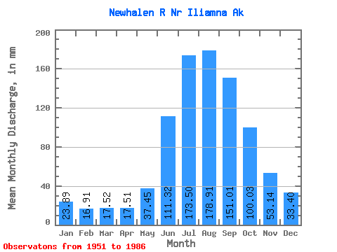
| Statistic | Jan | Feb | Mar | Apr | May | Jun | Jul | Aug | Sep | Oct | Nov | Dec | Annual |
|---|---|---|---|---|---|---|---|---|---|---|---|---|---|
| Mean | 23.89 | 17.06 | 17.52 | 17.50 | 37.45 | 111.32 | 173.48 | 178.88 | 151.00 | 100.02 | 53.14 | 33.40 | 905.11 |
| Standard Deviation | 7.23 | 5.11 | 5.00 | 5.37 | 9.99 | 24.82 | 26.52 | 26.64 | 32.40 | 29.52 | 16.25 | 10.92 | 94.47 |
| Min | 10.10 | 7.67 | 8.42 | 9.78 | 20.61 | 66.23 | 135.07 | 133.66 | 78.10 | 60.16 | 27.70 | 15.15 | 769.76 |
| Max | 38.67 | 27.06 | 28.05 | 26.66 | 53.68 | 160.95 | 218.39 | 251.52 | 207.23 | 167.55 | 88.83 | 53.94 | 1078.74 |
| Coefficient of Variation | 0.30 | 0.30 | 0.28 | 0.31 | 0.27 | 0.22 | 0.15 | 0.15 | 0.21 | 0.29 | 0.31 | 0.33 | 0.10 |
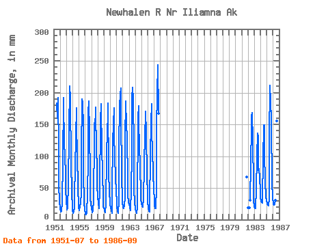
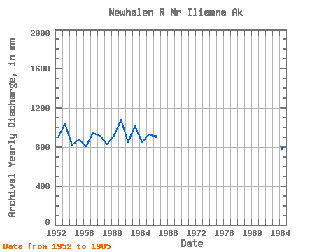
| Year | Jan | Feb | Mar | Apr | May | Jun | Jul | Aug | Sep | Oct | Nov | Dec | Annual | 1951 | 189.77 | 164.81 | 191.89 | 109.84 | 54.12 | 30.20 | 1952 | 18.87 | 11.90 | 13.90 | 15.89 | 26.24 | 95.44 | 191.26 | 197.80 | 113.47 | 110.06 | 63.51 | 47.03 | 899.70 | 1953 | 32.18 | 14.52 | 18.11 | 22.41 | 53.68 | 138.22 | 217.11 | 198.13 | 184.61 | 97.75 | 37.91 | 23.57 | 1033.46 | 1954 | 15.15 | 9.97 | 12.63 | 19.55 | 38.72 | 82.58 | 135.07 | 181.19 | 152.91 | 101.33 | 53.78 | 18.85 | 818.03 | 1955 | 18.98 | 13.75 | 22.32 | 24.44 | 45.82 | 103.23 | 195.74 | 189.49 | 147.97 | 76.24 | 27.70 | 15.15 | 876.26 | 1956 | 10.10 | 7.67 | 8.42 | 11.41 | 41.87 | 97.08 | 173.34 | 192.32 | 138.62 | 73.02 | 32.19 | 26.75 | 808.05 | 1957 | 16.81 | 11.92 | 11.79 | 14.26 | 30.17 | 130.72 | 157.29 | 145.15 | 176.35 | 106.89 | 88.83 | 53.94 | 941.69 | 1958 | 38.67 | 23.53 | 20.18 | 18.20 | 50.34 | 153.83 | 188.41 | 181.21 | 112.09 | 76.63 | 33.58 | 21.05 | 913.87 | 1959 | 19.36 | 13.81 | 11.79 | 11.41 | 25.07 | 101.26 | 146.59 | 166.00 | 182.90 | 77.22 | 42.80 | 29.79 | 825.50 | 1960 | 25.23 | 17.30 | 15.56 | 9.78 | 46.10 | 121.38 | 155.85 | 181.62 | 135.45 | 100.40 | 66.81 | 46.30 | 917.77 | 1961 | 27.78 | 18.41 | 14.31 | 10.59 | 32.07 | 115.10 | 185.20 | 204.02 | 207.23 | 167.55 | 72.11 | 28.81 | 1078.74 | 1962 | 19.77 | 18.00 | 18.52 | 22.25 | 36.91 | 126.02 | 192.97 | 153.27 | 132.11 | 63.60 | 38.45 | 27.78 | 846.53 | 1963 | 23.57 | 20.71 | 20.20 | 14.67 | 48.83 | 104.10 | 197.04 | 215.21 | 190.04 | 113.81 | 46.99 | 28.16 | 1018.57 | 1964 | 17.62 | 11.53 | 11.76 | 10.59 | 20.61 | 160.95 | 184.85 | 148.60 | 124.80 | 78.79 | 49.30 | 33.56 | 850.04 | 1965 | 26.10 | 19.94 | 21.05 | 21.18 | 32.26 | 85.58 | 140.61 | 168.39 | 170.46 | 140.26 | 66.81 | 42.93 | 931.94 | 1966 | 27.78 | 17.64 | 14.31 | 12.22 | 23.67 | 101.81 | 156.99 | 188.79 | 137.78 | 112.72 | 72.65 | 48.37 | 910.61 | 1967 | 32.26 | 21.04 | 18.30 | 17.71 | 52.90 | 144.93 | 206.19 | 251.52 | 166.93 | 1981 | 69.54 | 1982 | 19.53 | 19.95 | 31.33 | 89.01 | 149.14 | 167.47 | 168.64 | 127.42 | 54.48 | 32.34 | 1983 | 20.83 | 16.98 | 18.52 | 21.07 | 47.09 | 100.79 | 140.37 | 133.66 | 78.10 | 82.84 | 64.91 | 48.20 | 769.76 | 1984 | 36.36 | 27.06 | 28.05 | 26.66 | 36.58 | 92.57 | 153.51 | 153.76 | 105.73 | 60.16 | 36.72 | 29.98 | 784.14 | 1985 | 26.91 | 22.52 | 23.84 | 22.06 | 34.15 | 126.97 | 218.39 | 192.86 | 156.17 | 154.25 | 59.18 | 35.17 | 1067.27 | 1986 | 27.73 | 22.93 | 24.41 | 23.77 | 31.96 | 66.23 | 140.83 | 160.06 | 147.89 |
|---|
 Return to R-Arctic Net Home Page