|
|
|||||||||||||||||
| Point ID: 9378 | Downloads | Plots | Site Data | Code: 15300000 |
|
|
|||||||||||||||||
| Download | |
|---|---|
| Site Descriptor Information | Site Time Series Data |
| Link to all available data | |
| View: | Time Series | All |
| Units: | mm |
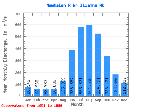
| Statistic | Jan | Feb | Mar | Apr | May | Jun | Jul | Aug | Sep | Oct | Nov | Dec | Annual |
|---|---|---|---|---|---|---|---|---|---|---|---|---|---|
| Mean | 80.34 | 62.97 | 58.93 | 60.84 | 125.96 | 386.89 | 583.53 | 601.70 | 524.79 | 336.42 | 184.69 | 112.34 | 258.34 |
| Standard Deviation | 24.31 | 18.88 | 16.82 | 18.67 | 33.62 | 86.26 | 89.20 | 89.62 | 112.58 | 99.29 | 56.49 | 36.73 | 26.97 |
| Min | 33.98 | 28.32 | 28.32 | 33.98 | 69.33 | 230.19 | 454.35 | 449.60 | 271.43 | 202.36 | 96.28 | 50.97 | 219.71 |
| Max | 130.07 | 99.89 | 94.34 | 92.63 | 180.56 | 559.35 | 734.59 | 846.03 | 720.19 | 563.60 | 308.72 | 181.43 | 307.90 |
| Coefficient of Variation | 0.30 | 0.30 | 0.28 | 0.31 | 0.27 | 0.22 | 0.15 | 0.15 | 0.21 | 0.29 | 0.31 | 0.33 | 0.10 |
 Return to R-Arctic Net Home Page