|
|
|||||||||||||||||
| Point ID: 9342 | Downloads | Plots | Site Data | Code: 15303150 |
|
|
|||||||||||||||||
| Download | |
|---|---|
| Site Descriptor Information | Site Time Series Data |
| Link to all available data | |
| View: | Time Series | All |
| Units: | m3/s |
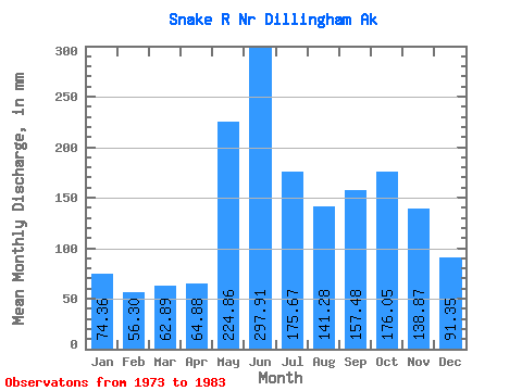
| Statistic | Jan | Feb | Mar | Apr | May | Jun | Jul | Aug | Sep | Oct | Nov | Dec | Annual |
|---|---|---|---|---|---|---|---|---|---|---|---|---|---|
| Mean | 74.35 | 56.79 | 62.88 | 64.88 | 224.82 | 297.91 | 175.64 | 141.26 | 157.47 | 176.03 | 138.87 | 91.33 | 1692.17 |
| Standard Deviation | 37.61 | 18.88 | 30.61 | 30.79 | 94.11 | 99.02 | 69.30 | 77.90 | 69.52 | 60.71 | 61.54 | 45.98 | 389.52 |
| Min | 32.34 | 28.07 | 30.25 | 23.86 | 79.29 | 184.21 | 95.34 | 58.17 | 59.81 | 82.67 | 64.35 | 30.76 | 1200.28 |
| Max | 160.30 | 86.22 | 129.29 | 140.51 | 379.93 | 460.81 | 292.82 | 323.41 | 324.04 | 270.49 | 277.83 | 189.68 | 2253.99 |
| Coefficient of Variation | 0.51 | 0.33 | 0.49 | 0.47 | 0.42 | 0.33 | 0.40 | 0.55 | 0.44 | 0.34 | 0.44 | 0.50 | 0.23 |
 Return to R-Arctic Net Home Page