|
|
|||||||||||||||||
| Point ID: 9342 | Downloads | Plots | Site Data | Code: 15303150 |
|
|
|||||||||||||||||
| Download | |
|---|---|
| Site Descriptor Information | Site Time Series Data |
| Link to all available data | |
|
|
| View: | Statistics | Time Series |
| Units: | m3/s |
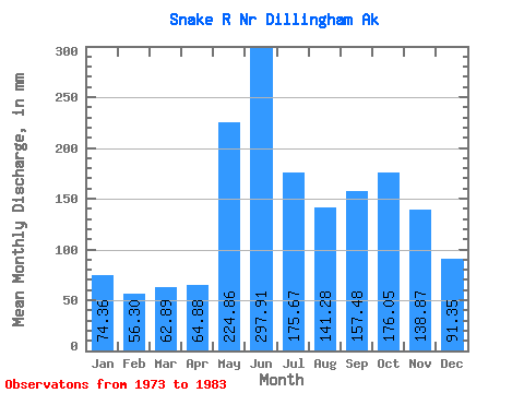
| Statistic | Jan | Feb | Mar | Apr | May | Jun | Jul | Aug | Sep | Oct | Nov | Dec | Annual |
|---|---|---|---|---|---|---|---|---|---|---|---|---|---|
| Mean | 74.35 | 56.79 | 62.88 | 64.88 | 224.82 | 297.91 | 175.64 | 141.26 | 157.47 | 176.03 | 138.87 | 91.33 | 1692.17 |
| Standard Deviation | 37.61 | 18.88 | 30.61 | 30.79 | 94.11 | 99.02 | 69.30 | 77.90 | 69.52 | 60.71 | 61.54 | 45.98 | 389.52 |
| Min | 32.34 | 28.07 | 30.25 | 23.86 | 79.29 | 184.21 | 95.34 | 58.17 | 59.81 | 82.67 | 64.35 | 30.76 | 1200.28 |
| Max | 160.30 | 86.22 | 129.29 | 140.51 | 379.93 | 460.81 | 292.82 | 323.41 | 324.04 | 270.49 | 277.83 | 189.68 | 2253.99 |
| Coefficient of Variation | 0.51 | 0.33 | 0.49 | 0.47 | 0.42 | 0.33 | 0.40 | 0.55 | 0.44 | 0.34 | 0.44 | 0.50 | 0.23 |
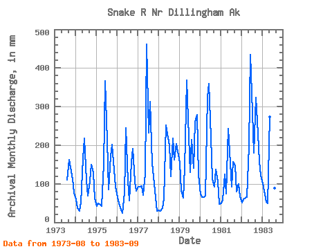
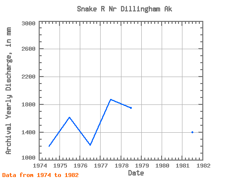
| Year | Jan | Feb | Mar | Apr | May | Jun | Jul | Aug | Sep | Oct | Nov | Dec | Annual | 1973 | 113.49 | 161.80 | 147.75 | 111.50 | 78.81 | 1974 | 62.26 | 33.81 | 30.25 | 50.74 | 170.98 | 217.74 | 112.57 | 70.90 | 107.43 | 154.15 | 127.34 | 64.02 | 1200.28 | 1975 | 43.46 | 47.21 | 46.63 | 41.63 | 154.36 | 365.94 | 218.69 | 88.41 | 170.82 | 208.40 | 134.78 | 95.11 | 1614.24 | 1976 | 67.53 | 47.21 | 34.68 | 23.86 | 79.29 | 245.04 | 111.05 | 58.17 | 155.56 | 197.24 | 105.18 | 85.14 | 1210.04 | 1977 | 94.85 | 86.22 | 96.31 | 71.22 | 131.04 | 460.81 | 240.09 | 323.41 | 153.59 | 121.89 | 64.35 | 30.76 | 1873.63 | 1978 | 32.34 | 28.07 | 37.27 | 61.89 | 260.06 | 228.36 | 205.79 | 122.39 | 218.39 | 167.83 | 203.01 | 189.68 | 1749.51 | 1979 | 160.30 | 76.80 | 66.53 | 140.51 | 379.93 | 267.14 | 134.84 | 221.06 | 139.97 | 268.54 | 277.83 | 126.79 | 2253.99 | 1980 | 75.89 | 62.19 | 67.36 | 69.88 | 334.61 | 359.00 | 228.71 | 116.32 | 92.41 | 141.30 | 106.31 | 48.91 | 1698.77 | 1981 | 50.06 | 54.04 | 129.29 | 74.12 | 251.26 | 184.21 | 95.34 | 161.66 | 148.41 | 82.67 | 98.98 | 68.70 | 1395.32 | 1982 | 52.06 | 56.36 | 66.48 | 65.28 | 203.84 | 434.73 | 292.82 | 185.45 | 324.04 | 270.49 | 159.42 | 125.45 | 2233.78 | 1983 | 104.72 | 75.96 | 53.99 | 49.65 | 282.90 | 216.08 | 116.49 | 92.57 | 59.81 |
|---|
 Return to R-Arctic Net Home Page