|
|
|||||||||||||||||
| Point ID: 9342 | Downloads | Plots | Site Data | Code: 15303150 |
|
|
|||||||||||||||||
| Download | |
|---|---|
| Site Descriptor Information | Site Time Series Data |
| Link to all available data | |
| View: | Time Series | All |
| Units: | mm |
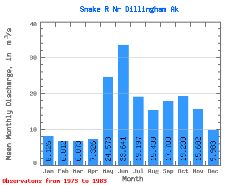
| Statistic | Jan | Feb | Mar | Apr | May | Jun | Jul | Aug | Sep | Oct | Nov | Dec | Annual |
|---|---|---|---|---|---|---|---|---|---|---|---|---|---|
| Mean | 8.13 | 6.81 | 6.87 | 7.33 | 24.57 | 33.64 | 19.20 | 15.44 | 17.78 | 19.24 | 15.68 | 9.98 | 15.69 |
| Standard Deviation | 4.11 | 2.27 | 3.35 | 3.48 | 10.29 | 11.18 | 7.58 | 8.51 | 7.85 | 6.64 | 6.95 | 5.03 | 3.61 |
| Min | 3.54 | 3.37 | 3.31 | 2.69 | 8.67 | 20.80 | 10.42 | 6.36 | 6.75 | 9.04 | 7.27 | 3.36 | 11.13 |
| Max | 17.52 | 10.34 | 14.13 | 15.87 | 41.52 | 52.04 | 32.01 | 35.35 | 36.59 | 29.56 | 31.37 | 20.73 | 20.90 |
| Coefficient of Variation | 0.51 | 0.33 | 0.49 | 0.47 | 0.42 | 0.33 | 0.40 | 0.55 | 0.44 | 0.34 | 0.44 | 0.50 | 0.23 |
 Return to R-Arctic Net Home Page