|
|
|||||||||||||||||
| Point ID: 9330 | Downloads | Plots | Site Data | Code: 15068000 |
|
|
|||||||||||||||||
| Download | |
|---|---|
| Site Descriptor Information | Site Time Series Data |
| Link to all available data | |
| View: | Time Series | All |
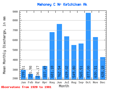
| Units: | m3/s |
| Statistic | Jan | Feb | Mar | Apr | May | Jun | Jul | Aug | Sep | Oct | Nov | Dec | Annual |
|---|---|---|---|---|---|---|---|---|---|---|---|---|---|
| Mean | 299.40 | 258.19 | 236.15 | 337.41 | 681.01 | 762.62 | 638.87 | 549.70 | 565.43 | 876.90 | 630.30 | 428.14 | 6344.86 |
| Standard Deviation | 238.85 | 192.42 | 126.50 | 142.27 | 156.13 | 157.62 | 204.76 | 261.30 | 261.35 | 291.03 | 290.21 | 293.62 | 871.77 |
| Min | 24.32 | 63.01 | 74.06 | 139.18 | 438.99 | 494.42 | 207.36 | 163.96 | 93.73 | 371.22 | 177.74 | 143.30 | 4776.36 |
| Max | 905.76 | 842.00 | 687.41 | 742.06 | 1009.56 | 1109.71 | 1034.83 | 1157.17 | 996.17 | 1443.59 | 1339.85 | 1479.16 | 7959.66 |
| Coefficient of Variation | 0.80 | 0.74 | 0.54 | 0.42 | 0.23 | 0.21 | 0.32 | 0.47 | 0.46 | 0.33 | 0.46 | 0.69 | 0.14 |
 Return to R-Arctic Net Home Page