|
|
|||||||||||||||||
| Point ID: 9330 | Downloads | Plots | Site Data | Code: 15068000 |
|
|
|||||||||||||||||
| Download | |
|---|---|
| Site Descriptor Information | Site Time Series Data |
| Link to all available data | |
| View: | Time Series | All |
| Units: | mm |
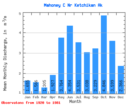
| Statistic | Jan | Feb | Mar | Apr | May | Jun | Jul | Aug | Sep | Oct | Nov | Dec | Annual |
|---|---|---|---|---|---|---|---|---|---|---|---|---|---|
| Mean | 1.66 | 1.57 | 1.30 | 1.93 | 3.76 | 4.35 | 3.53 | 3.04 | 3.23 | 4.85 | 3.60 | 2.37 | 2.98 |
| Standard Deviation | 1.32 | 1.17 | 0.70 | 0.81 | 0.86 | 0.90 | 1.13 | 1.44 | 1.49 | 1.61 | 1.66 | 1.62 | 0.41 |
| Min | 0.13 | 0.38 | 0.41 | 0.80 | 2.43 | 2.82 | 1.15 | 0.91 | 0.54 | 2.05 | 1.01 | 0.79 | 2.24 |
| Max | 5.01 | 5.11 | 3.80 | 4.24 | 5.58 | 6.34 | 5.72 | 6.39 | 5.69 | 7.98 | 7.65 | 8.18 | 3.73 |
| Coefficient of Variation | 0.80 | 0.74 | 0.54 | 0.42 | 0.23 | 0.21 | 0.32 | 0.47 | 0.46 | 0.33 | 0.46 | 0.69 | 0.14 |
 Return to R-Arctic Net Home Page