|
|
|||||||||||||||||
| Point ID: 9330 | Downloads | Plots | Site Data | Code: 15068000 |
|
|
|||||||||||||||||
| Download | |
|---|---|
| Site Descriptor Information | Site Time Series Data |
| Link to all available data | |
|
|
| View: | Statistics | Time Series |
| Units: | m3/s |
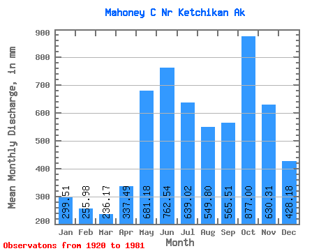
| Statistic | Jan | Feb | Mar | Apr | May | Jun | Jul | Aug | Sep | Oct | Nov | Dec | Annual |
|---|---|---|---|---|---|---|---|---|---|---|---|---|---|
| Mean | 299.40 | 258.19 | 236.15 | 337.41 | 681.01 | 762.62 | 638.87 | 549.70 | 565.43 | 876.90 | 630.30 | 428.14 | 6344.86 |
| Standard Deviation | 238.85 | 192.42 | 126.50 | 142.27 | 156.13 | 157.62 | 204.76 | 261.30 | 261.35 | 291.03 | 290.21 | 293.62 | 871.77 |
| Min | 24.32 | 63.01 | 74.06 | 139.18 | 438.99 | 494.42 | 207.36 | 163.96 | 93.73 | 371.22 | 177.74 | 143.30 | 4776.36 |
| Max | 905.76 | 842.00 | 687.41 | 742.06 | 1009.56 | 1109.71 | 1034.83 | 1157.17 | 996.17 | 1443.59 | 1339.85 | 1479.16 | 7959.66 |
| Coefficient of Variation | 0.80 | 0.74 | 0.54 | 0.42 | 0.23 | 0.21 | 0.32 | 0.47 | 0.46 | 0.33 | 0.46 | 0.69 | 0.14 |
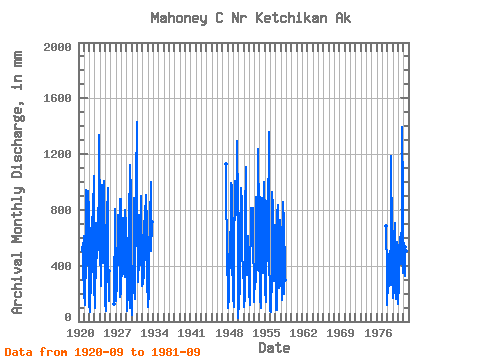
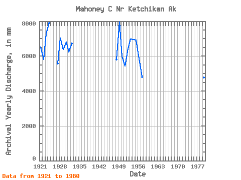
| Year | Jan | Feb | Mar | Apr | May | Jun | Jul | Aug | Sep | Oct | Nov | Dec | Annual | 1920 | 502.06 | 584.60 | 356.90 | 237.34 | 1921 | 173.22 | 577.37 | 124.46 | 176.22 | 453.72 | 939.10 | 577.76 | 545.63 | 705.06 | 964.45 | 408.65 | 882.45 | 6539.09 | 1922 | 128.10 | 63.01 | 107.64 | 297.64 | 618.67 | 749.85 | 544.10 | 369.41 | 804.25 | 807.90 | 1043.95 | 281.00 | 5811.68 | 1923 | 97.34 | 359.81 | 319.65 | 573.45 | 732.70 | 664.22 | 471.73 | 661.13 | 816.96 | 528.11 | 1339.85 | 715.52 | 7295.02 | 1924 | 421.33 | 609.64 | 276.69 | 251.44 | 1009.56 | 725.24 | 871.80 | 431.39 | 866.05 | 1024.44 | 1008.72 | 393.73 | 7899.84 | 1925 | 145.46 | 70.07 | 245.11 | 337.22 | 783.78 | 955.15 | 948.88 | 421.81 | 146.28 | 371.22 | 1926 | 126.97 | 835.20 | 376.91 | 543.14 | 1927 | 288.75 | 138.59 | 282.31 | 269.95 | 542.16 | 763.08 | 737.90 | 595.84 | 672.16 | 910.23 | 177.74 | 216.21 | 5569.19 | 1928 | 905.76 | 309.56 | 687.41 | 338.09 | 762.96 | 661.91 | 633.13 | 406.59 | 317.73 | 824.76 | 683.21 | 539.48 | 7038.76 | 1929 | 554.53 | 69.37 | 301.14 | 154.21 | 483.14 | 728.19 | 736.99 | 1157.17 | 93.73 | 1044.58 | 919.11 | 187.44 | 6382.81 | 1930 | 51.31 | 372.47 | 209.75 | 308.81 | 438.99 | 886.05 | 392.65 | 163.96 | 402.86 | 1114.98 | 988.37 | 1479.16 | 6807.32 | 1931 | 717.28 | 351.94 | 293.59 | 451.29 | 788.08 | 545.51 | 557.49 | 418.32 | 590.96 | 929.06 | 345.81 | 264.12 | 6238.10 | 1932 | 454.54 | 393.25 | 279.65 | 340.20 | 645.45 | 820.60 | 855.87 | 453.04 | 907.04 | 705.60 | 643.21 | 214.71 | 6718.81 | 1933 | 269.58 | 95.56 | 218.18 | 529.01 | 710.78 | 711.16 | 1034.83 | 995.18 | 507.99 | 738.02 | 1947 | 1164.10 | 334.75 | 382.15 | 1948 | 498.17 | 93.69 | 183.30 | 139.18 | 640.67 | 639.59 | 525.47 | 441.64 | 996.17 | 1006.60 | 503.36 | 152.23 | 5798.93 | 1949 | 229.43 | 95.03 | 279.99 | 742.06 | 753.86 | 1005.07 | 790.01 | 867.23 | 913.16 | 1338.14 | 822.75 | 143.30 | 7959.66 | 1950 | 24.32 | 132.97 | 151.25 | 234.07 | 627.58 | 953.67 | 949.06 | 725.45 | 897.46 | 526.09 | 344.34 | 433.87 | 5984.50 | 1951 | 203.96 | 94.80 | 182.88 | 265.15 | 789.58 | 1109.71 | 691.76 | 478.15 | 335.59 | 630.07 | 388.32 | 299.33 | 5448.68 | 1952 | 214.36 | 211.52 | 123.77 | 442.37 | 658.51 | 812.19 | 841.76 | 772.38 | 816.46 | 705.60 | 534.11 | 306.45 | 6429.24 | 1953 | 146.44 | 301.13 | 261.99 | 297.23 | 919.65 | 601.90 | 692.12 | 383.79 | 810.52 | 1279.80 | 731.68 | 587.10 | 6995.95 | 1954 | 140.75 | 842.00 | 97.82 | 178.53 | 659.83 | 887.23 | 646.70 | 362.79 | 422.20 | 911.22 | 1002.76 | 767.43 | 6957.12 | 1955 | 386.94 | 212.59 | 146.44 | 400.38 | 476.02 | 865.39 | 662.99 | 1058.48 | 681.40 | 1402.26 | 489.64 | 166.28 | 6923.95 | 1956 | 76.12 | 99.32 | 74.06 | 343.69 | 959.98 | 819.45 | 524.92 | 693.04 | 290.94 | 627.41 | 643.73 | 715.69 | 5841.05 | 1957 | 126.70 | 74.73 | 86.27 | 247.99 | 788.39 | 834.96 | 570.34 | 244.63 | 358.89 | 488.92 | 726.36 | 262.47 | 4802.27 | 1958 | 648.40 | 341.95 | 159.66 | 498.42 | 886.92 | 494.42 | 207.36 | 804.10 | 297.56 | 1977 | 703.96 | 339.86 | 159.82 | 1978 | 125.16 | 263.44 | 251.24 | 258.38 | 479.48 | 508.01 | 311.77 | 272.56 | 392.61 | 1227.40 | 583.04 | 459.81 | 5122.86 | 1979 | 181.49 | 157.56 | 337.86 | 205.47 | 608.90 | 704.39 | 478.60 | 169.91 | 556.11 | 591.71 | 386.98 | 407.76 | 4776.36 | 1980 | 130.40 | 257.88 | 254.20 | 506.00 | 614.36 | 574.12 | 658.10 | 428.10 | 481.72 | 1443.59 | 893.99 | 361.82 | 6590.69 | 1981 | 743.95 | 381.80 | 439.65 | 323.50 | 553.51 | 630.66 | 335.29 | 520.16 | 686.70 |
|---|
 Return to R-Arctic Net Home Page