|
|
|||||||||||||||||
| Point ID: 9328 | Downloads | Plots | Site Data | Code: 15066000 |
|
|
|||||||||||||||||
| Download | |
|---|---|
| Site Descriptor Information | Site Time Series Data |
| Link to all available data | |
| View: | Time Series | All |
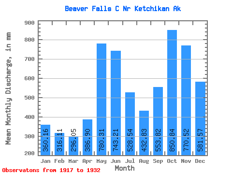
| Units: | m3/s |
| Statistic | Jan | Feb | Mar | Apr | May | Jun | Jul | Aug | Sep | Oct | Nov | Dec | Annual |
|---|---|---|---|---|---|---|---|---|---|---|---|---|---|
| Mean | 360.05 | 318.88 | 296.07 | 386.95 | 780.11 | 743.25 | 528.53 | 432.76 | 553.88 | 850.69 | 770.48 | 581.45 | 6678.06 |
| Standard Deviation | 291.02 | 200.31 | 147.82 | 142.11 | 174.29 | 178.58 | 135.25 | 216.86 | 282.30 | 229.75 | 343.54 | 406.77 | 559.90 |
| Min | 59.85 | 61.52 | 107.11 | 226.73 | 482.24 | 514.13 | 301.54 | 124.91 | 77.48 | 464.60 | 160.01 | 247.73 | 5908.84 |
| Max | 847.03 | 612.81 | 656.40 | 694.50 | 1105.84 | 1038.64 | 724.13 | 832.52 | 1007.51 | 1251.64 | 1208.63 | 1288.02 | 7592.52 |
| Coefficient of Variation | 0.81 | 0.63 | 0.50 | 0.37 | 0.22 | 0.24 | 0.26 | 0.50 | 0.51 | 0.27 | 0.45 | 0.70 | 0.08 |
 Return to R-Arctic Net Home Page