|
|
|||||||||||||||||
| Point ID: 9328 | Downloads | Plots | Site Data | Code: 15066000 |
|
|
|||||||||||||||||
| Download | |
|---|---|
| Site Descriptor Information | Site Time Series Data |
| Link to all available data | |
| View: | Time Series | All |
| Units: | mm |
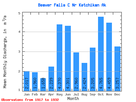
| Statistic | Jan | Feb | Mar | Apr | May | Jun | Jul | Aug | Sep | Oct | Nov | Dec | Annual |
|---|---|---|---|---|---|---|---|---|---|---|---|---|---|
| Mean | 2.02 | 1.96 | 1.66 | 2.24 | 4.37 | 4.30 | 2.96 | 2.42 | 3.21 | 4.76 | 4.46 | 3.26 | 3.17 |
| Standard Deviation | 1.63 | 1.23 | 0.83 | 0.82 | 0.98 | 1.03 | 0.76 | 1.22 | 1.63 | 1.29 | 1.99 | 2.28 | 0.27 |
| Min | 0.34 | 0.38 | 0.60 | 1.31 | 2.70 | 2.98 | 1.69 | 0.70 | 0.45 | 2.60 | 0.93 | 1.39 | 2.81 |
| Max | 4.74 | 3.77 | 3.68 | 4.02 | 6.19 | 6.01 | 4.06 | 4.66 | 5.83 | 7.01 | 6.99 | 7.21 | 3.61 |
| Coefficient of Variation | 0.81 | 0.63 | 0.50 | 0.37 | 0.22 | 0.24 | 0.26 | 0.50 | 0.51 | 0.27 | 0.45 | 0.70 | 0.08 |
 Return to R-Arctic Net Home Page