|
|
| Point ID: 9328 | Downloads | Plots | Site Data | Code: 15066000 |
|
| Download | |
|---|---|
| Site Descriptor Information | Site Time Series Data |
| Link to all available data | |
|
|
|
| View: | Statistics | All |
| Units: | m3/s |
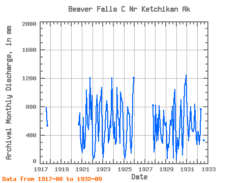
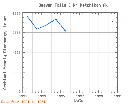
| Year | Jan | Feb | Mar | Apr | May | Jun | Jul | Aug | Sep | Oct | Nov | Dec | Annual | 1917 | 820.77 | 534.49 | 1920 | 551.30 | 738.27 | 374.85 | 247.73 | 1921 | 160.47 | 612.81 | 207.59 | 226.73 | 641.38 | 1038.64 | 597.37 | 495.94 | 743.44 | 1251.64 | 620.77 | 987.29 | 7592.52 | 1922 | 126.40 | 62.19 | 107.11 | 355.26 | 781.80 | 961.51 | 461.33 | 325.67 | 851.09 | 937.88 | 1071.78 | 288.18 | 6328.30 | 1923 | 82.84 | 336.26 | 392.20 | 694.50 | 914.71 | 690.27 | 301.54 | 370.36 | 598.61 | 522.19 | 1208.63 | 613.36 | 6741.13 | 1924 | 369.06 | 548.17 | 275.13 | 315.11 | 1105.84 | 638.06 | 629.69 | 288.81 | 1007.51 | 933.78 | 847.96 | 360.57 | 7332.48 | 1925 | 147.75 | 69.08 | 227.51 | 344.97 | 826.51 | 703.29 | 724.13 | 374.28 | 149.73 | 464.60 | 912.41 | 1251.34 | 6159.85 | 1927 | 846.88 | 160.01 | 258.18 | 1928 | 847.03 | 292.73 | 656.40 | 331.12 | 841.64 | 552.42 | 461.51 | 324.71 | 285.26 | 773.82 | 576.08 | 553.97 | 6465.17 | 1929 | 605.99 | 61.52 | 279.84 | 227.68 | 482.24 | 613.26 | 549.35 | 832.52 | 77.48 | 906.73 | 1039.79 | 269.23 | 5908.84 | 1930 | 59.85 | 341.21 | 210.20 | 396.66 | 597.52 | 901.47 | 388.31 | 124.91 | 511.84 | 1122.34 | 1149.24 | 1288.02 | 7093.56 | 1931 | 746.10 | 445.67 | 326.81 | 534.97 | 823.73 | 514.13 | 476.15 | 464.48 | 503.66 | 859.44 | 513.73 | 278.07 | 6480.73 | 1932 | 455.02 | 419.15 | 277.88 | 442.49 | 785.73 | 819.44 | 695.92 | 337.94 | 832.18 |
|---|
 Return to R-Arctic Net Home Page