|
|
|||||||||||||||||
| Point ID: 9325 | Downloads | Plots | Site Data | Code: 15060000 |
|
|
|||||||||||||||||
| Download | |
|---|---|
| Site Descriptor Information | Site Time Series Data |
| Link to all available data | |
| View: | Time Series | All |
| Units: | m3/s |
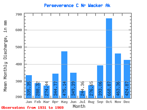
| Statistic | Jan | Feb | Mar | Apr | May | Jun | Jul | Aug | Sep | Oct | Nov | Dec | Annual |
|---|---|---|---|---|---|---|---|---|---|---|---|---|---|
| Mean | 335.30 | 290.95 | 274.26 | 344.79 | 475.12 | 349.31 | 244.29 | 276.57 | 393.13 | 668.72 | 463.22 | 424.66 | 4571.77 |
| Standard Deviation | 203.63 | 211.31 | 158.90 | 134.17 | 157.79 | 162.18 | 133.60 | 180.75 | 189.23 | 201.17 | 166.31 | 225.42 | 641.98 |
| Min | 26.05 | 27.44 | 63.70 | 106.75 | 227.87 | 18.84 | 35.95 | 26.45 | 90.32 | 318.69 | 252.31 | 100.07 | 3060.49 |
| Max | 792.19 | 884.49 | 624.29 | 786.25 | 811.26 | 723.61 | 531.20 | 628.50 | 750.14 | 1082.08 | 849.60 | 1006.95 | 6092.93 |
| Coefficient of Variation | 0.61 | 0.73 | 0.58 | 0.39 | 0.33 | 0.46 | 0.55 | 0.65 | 0.48 | 0.30 | 0.36 | 0.53 | 0.14 |
 Return to R-Arctic Net Home Page