|
|
|||||||||||||||||
| Point ID: 9325 | Downloads | Plots | Site Data | Code: 15060000 |
|
|
|||||||||||||||||
| Download | |
|---|---|
| Site Descriptor Information | Site Time Series Data |
| Link to all available data | |
|
|
| View: | Statistics | Time Series |
| Units: | m3/s |
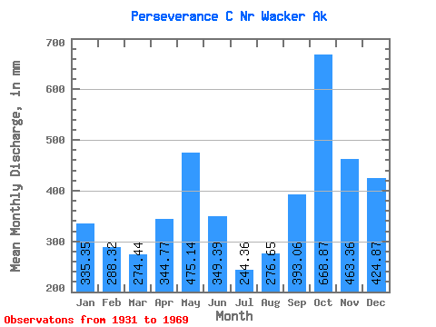
| Statistic | Jan | Feb | Mar | Apr | May | Jun | Jul | Aug | Sep | Oct | Nov | Dec | Annual |
|---|---|---|---|---|---|---|---|---|---|---|---|---|---|
| Mean | 335.30 | 290.95 | 274.26 | 344.79 | 475.12 | 349.31 | 244.29 | 276.57 | 393.13 | 668.72 | 463.22 | 424.66 | 4571.77 |
| Standard Deviation | 203.63 | 211.31 | 158.90 | 134.17 | 157.79 | 162.18 | 133.60 | 180.75 | 189.23 | 201.17 | 166.31 | 225.42 | 641.98 |
| Min | 26.05 | 27.44 | 63.70 | 106.75 | 227.87 | 18.84 | 35.95 | 26.45 | 90.32 | 318.69 | 252.31 | 100.07 | 3060.49 |
| Max | 792.19 | 884.49 | 624.29 | 786.25 | 811.26 | 723.61 | 531.20 | 628.50 | 750.14 | 1082.08 | 849.60 | 1006.95 | 6092.93 |
| Coefficient of Variation | 0.61 | 0.73 | 0.58 | 0.39 | 0.33 | 0.46 | 0.55 | 0.65 | 0.48 | 0.30 | 0.36 | 0.53 | 0.14 |
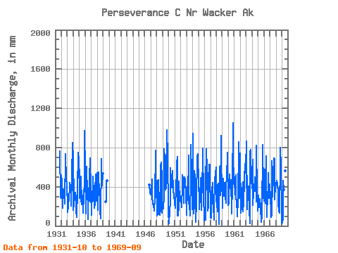
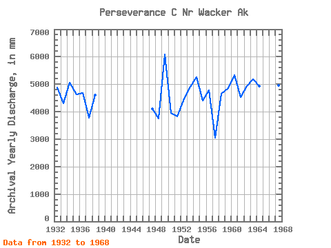
| Year | Jan | Feb | Mar | Apr | May | Jun | Jul | Aug | Sep | Oct | Nov | Dec | Annual | 1931 | 790.47 | 290.87 | 293.56 | 1932 | 530.77 | 425.69 | 235.92 | 183.71 | 391.06 | 325.77 | 418.57 | 235.23 | 734.31 | 475.19 | 586.17 | 320.66 | 4876.26 | 1933 | 337.43 | 128.77 | 211.41 | 298.28 | 377.97 | 443.06 | 415.64 | 343.16 | 203.48 | 531.48 | 849.60 | 169.57 | 4303.28 | 1934 | 792.19 | 188.96 | 319.68 | 331.79 | 349.18 | 286.55 | 150.78 | 90.79 | 365.31 | 776.06 | 725.26 | 711.08 | 5070.26 | 1935 | 295.30 | 545.22 | 321.99 | 249.03 | 520.03 | 216.83 | 256.80 | 321.34 | 133.02 | 318.69 | 438.02 | 1006.95 | 4626.24 | 1936 | 572.34 | 116.24 | 624.29 | 375.38 | 474.16 | 65.38 | 398.40 | 260.12 | 256.02 | 493.56 | 693.44 | 373.94 | 4675.38 | 1937 | 114.09 | 123.00 | 363.55 | 321.69 | 519.46 | 319.74 | 188.93 | 239.60 | 362.32 | 547.55 | 254.74 | 443.32 | 3782.80 | 1938 | 558.27 | 371.58 | 163.50 | 548.62 | 320.34 | 329.51 | 157.38 | 76.83 | 682.17 | 430.06 | 412.87 | 550.51 | 4619.22 | 1939 | 247.71 | 264.50 | 451.05 | 459.19 | 1946 | 435.17 | 338.84 | 328.32 | 1947 | 371.55 | 337.02 | 494.69 | 313.04 | 227.87 | 222.76 | 218.64 | 158.88 | 284.37 | 792.82 | 293.63 | 390.40 | 4100.74 | 1948 | 480.88 | 98.06 | 194.16 | 115.46 | 488.55 | 221.34 | 112.99 | 173.81 | 602.72 | 672.82 | 478.91 | 137.34 | 3764.88 | 1949 | 233.25 | 162.13 | 312.05 | 786.25 | 712.08 | 723.61 | 380.79 | 395.07 | 527.94 | 1007.96 | 712.50 | 143.54 | 6092.93 | 1950 | 26.05 | 38.10 | 149.73 | 246.50 | 611.92 | 467.87 | 404.27 | 422.29 | 562.39 | 376.33 | 315.16 | 338.73 | 3944.07 | 1951 | 229.48 | 172.19 | 281.15 | 309.68 | 658.78 | 708.17 | 108.22 | 105.08 | 207.64 | 473.27 | 252.31 | 315.44 | 3817.74 | 1952 | 299.83 | 259.96 | 192.95 | 426.20 | 536.50 | 486.98 | 242.12 | 284.38 | 500.11 | 488.11 | 336.33 | 357.25 | 4413.69 | 1953 | 113.12 | 372.47 | 354.90 | 288.74 | 741.92 | 228.91 | 236.62 | 108.23 | 506.65 | 853.14 | 526.20 | 571.03 | 4900.35 | 1954 | 175.33 | 884.49 | 129.06 | 219.55 | 583.68 | 493.34 | 224.15 | 40.63 | 244.35 | 741.78 | 713.88 | 762.86 | 5258.85 | 1955 | 429.50 | 265.34 | 171.51 | 298.20 | 490.90 | 494.00 | 167.28 | 561.02 | 343.02 | 818.64 | 283.92 | 100.07 | 4415.89 | 1956 | 53.25 | 153.73 | 63.70 | 437.01 | 811.26 | 574.12 | 159.95 | 561.97 | 184.14 | 518.76 | 630.09 | 644.92 | 4781.04 | 1957 | 83.31 | 75.87 | 84.88 | 362.61 | 455.07 | 247.34 | 221.58 | 63.86 | 195.28 | 458.84 | 560.06 | 254.98 | 3060.49 | 1958 | 621.61 | 214.48 | 148.31 | 403.62 | 448.16 | 18.84 | 35.95 | 628.50 | 310.29 | 954.34 | 377.50 | 536.84 | 4670.84 | 1959 | 190.91 | 232.61 | 500.58 | 304.67 | 456.05 | 408.89 | 298.98 | 243.01 | 288.20 | 632.15 | 551.70 | 771.40 | 4864.55 | 1960 | 217.60 | 210.68 | 544.02 | 448.77 | 394.77 | 380.70 | 484.24 | 127.42 | 416.32 | 1082.08 | 429.63 | 611.41 | 5326.54 | 1961 | 424.74 | 439.14 | 328.45 | 519.81 | 280.10 | 268.25 | 102.72 | 287.48 | 220.37 | 887.31 | 483.17 | 289.68 | 4540.76 | 1962 | 766.26 | 122.32 | 202.89 | 392.78 | 297.93 | 449.79 | 148.94 | 246.95 | 459.04 | 571.17 | 540.25 | 753.12 | 4934.26 | 1963 | 406.82 | 811.78 | 172.12 | 340.43 | 293.36 | 404.56 | 172.42 | 26.45 | 750.14 | 803.55 | 436.04 | 526.29 | 5192.36 | 1964 | 396.84 | 637.38 | 221.55 | 350.61 | 363.92 | 499.72 | 369.42 | 475.19 | 250.35 | 849.95 | 340.72 | 162.08 | 4937.45 | 1965 | 320.69 | 296.12 | 193.48 | 249.03 | 283.83 | 191.12 | 42.92 | 47.78 | 90.32 | 858.51 | 352.10 | 307.37 | 3232.55 | 1966 | 259.81 | 254.04 | 594.95 | 234.95 | 736.89 | 355.95 | 90.98 | 342.35 | 372.36 | 557.25 | 282.20 | 439.03 | 4504.57 | 1967 | 296.91 | 327.92 | 95.10 | 106.75 | 682.25 | 296.61 | 531.20 | 536.96 | 690.43 | 707.05 | 267.85 | 428.17 | 4953.95 | 1968 | 433.49 | 435.70 | 478.76 | 420.64 | 365.61 | 230.74 | 153.34 | 139.58 | 687.74 | 826.34 | 606.00 | 124.47 | 4919.55 | 1969 | 27.28 | 27.44 | 78.34 | 459.82 | 380.03 | 220.40 | 414.17 | 578.67 | 296.93 |
|---|
 Return to R-Arctic Net Home Page