|
|
|||||||||||||||||
| Point ID: 9325 | Downloads | Plots | Site Data | Code: 15060000 |
|
|
|||||||||||||||||
| Download | |
|---|---|
| Site Descriptor Information | Site Time Series Data |
| Link to all available data | |
| View: | Time Series | All |
| Units: | mm |
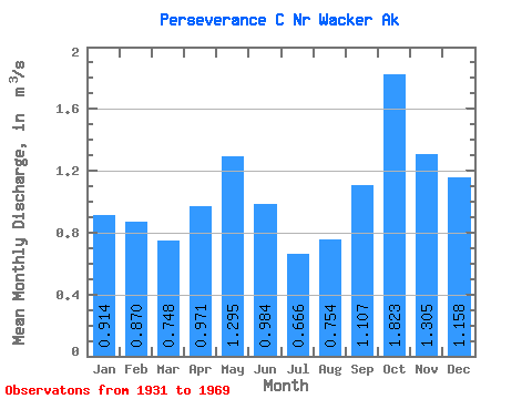
| Statistic | Jan | Feb | Mar | Apr | May | Jun | Jul | Aug | Sep | Oct | Nov | Dec | Annual |
|---|---|---|---|---|---|---|---|---|---|---|---|---|---|
| Mean | 0.91 | 0.87 | 0.75 | 0.97 | 1.29 | 0.98 | 0.67 | 0.75 | 1.11 | 1.82 | 1.30 | 1.16 | 1.06 |
| Standard Deviation | 0.56 | 0.63 | 0.43 | 0.38 | 0.43 | 0.46 | 0.36 | 0.49 | 0.53 | 0.55 | 0.47 | 0.61 | 0.15 |
| Min | 0.07 | 0.08 | 0.17 | 0.30 | 0.62 | 0.05 | 0.10 | 0.07 | 0.25 | 0.87 | 0.71 | 0.27 | 0.71 |
| Max | 2.16 | 2.65 | 1.70 | 2.21 | 2.21 | 2.04 | 1.45 | 1.71 | 2.11 | 2.95 | 2.39 | 2.75 | 1.41 |
| Coefficient of Variation | 0.61 | 0.73 | 0.58 | 0.39 | 0.33 | 0.46 | 0.55 | 0.65 | 0.48 | 0.30 | 0.36 | 0.53 | 0.14 |
 Return to R-Arctic Net Home Page