|
|
|||||||||||||||||
| Point ID: 9322 | Downloads | Plots | Site Data | Code: 15074000 |
|
|
|||||||||||||||||
| Download | |
|---|---|
| Site Descriptor Information | Site Time Series Data |
| Link to all available data | |
| View: | Time Series | All |
| Units: | m3/s |
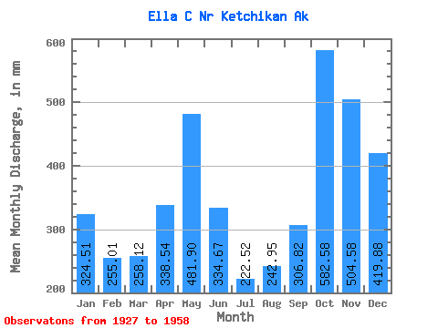
| Statistic | Jan | Feb | Mar | Apr | May | Jun | Jul | Aug | Sep | Oct | Nov | Dec | Annual |
|---|---|---|---|---|---|---|---|---|---|---|---|---|---|
| Mean | 324.46 | 257.22 | 258.07 | 338.54 | 481.86 | 334.65 | 222.50 | 242.92 | 306.83 | 582.48 | 504.57 | 419.81 | 4265.50 |
| Standard Deviation | 199.31 | 174.58 | 113.84 | 123.84 | 99.42 | 136.26 | 72.96 | 128.32 | 142.25 | 156.21 | 193.98 | 227.15 | 535.11 |
| Min | 37.56 | 70.08 | 93.62 | 116.91 | 278.15 | 76.90 | 115.63 | 62.21 | 99.40 | 309.85 | 210.74 | 131.42 | 3091.96 |
| Max | 690.45 | 716.34 | 452.74 | 634.81 | 672.13 | 575.66 | 405.32 | 468.28 | 608.77 | 894.64 | 1029.62 | 1106.84 | 5038.57 |
| Coefficient of Variation | 0.61 | 0.68 | 0.44 | 0.37 | 0.21 | 0.41 | 0.33 | 0.53 | 0.46 | 0.27 | 0.38 | 0.54 | 0.12 |
 Return to R-Arctic Net Home Page