|
|
|||||||||||||||||
| Point ID: 9322 | Downloads | Plots | Site Data | Code: 15074000 |
|
|
|||||||||||||||||
| Download | |
|---|---|
| Site Descriptor Information | Site Time Series Data |
| Link to all available data | |
|
|
| View: | Statistics | Time Series |
| Units: | m3/s |
| Statistic | Jan | Feb | Mar | Apr | May | Jun | Jul | Aug | Sep | Oct | Nov | Dec | Annual |
|---|---|---|---|---|---|---|---|---|---|---|---|---|---|
| Mean | 324.46 | 257.22 | 258.07 | 338.54 | 481.86 | 334.65 | 222.50 | 242.92 | 306.83 | 582.48 | 504.57 | 419.81 | 4265.50 |
| Standard Deviation | 199.31 | 174.58 | 113.84 | 123.84 | 99.42 | 136.26 | 72.96 | 128.32 | 142.25 | 156.21 | 193.98 | 227.15 | 535.11 |
| Min | 37.56 | 70.08 | 93.62 | 116.91 | 278.15 | 76.90 | 115.63 | 62.21 | 99.40 | 309.85 | 210.74 | 131.42 | 3091.96 |
| Max | 690.45 | 716.34 | 452.74 | 634.81 | 672.13 | 575.66 | 405.32 | 468.28 | 608.77 | 894.64 | 1029.62 | 1106.84 | 5038.57 |
| Coefficient of Variation | 0.61 | 0.68 | 0.44 | 0.37 | 0.21 | 0.41 | 0.33 | 0.53 | 0.46 | 0.27 | 0.38 | 0.54 | 0.12 |
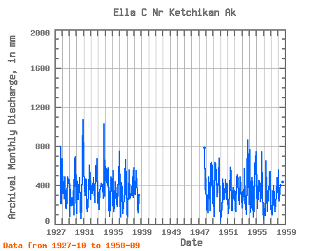
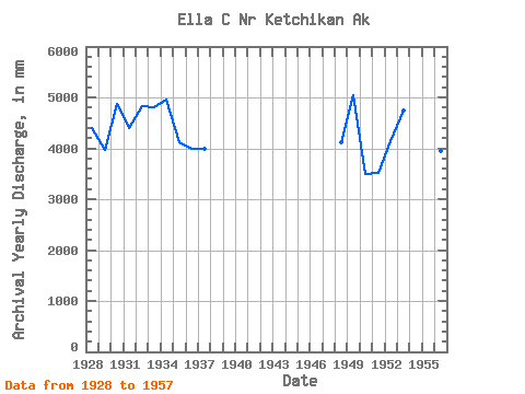
| Year | Jan | Feb | Mar | Apr | May | Jun | Jul | Aug | Sep | Oct | Nov | Dec | Annual | 1927 | 822.79 | 210.74 | 220.83 | 1928 | 690.45 | 302.06 | 450.87 | 261.45 | 498.74 | 210.06 | 173.18 | 163.18 | 254.87 | 498.88 | 438.70 | 468.48 | 4398.78 | 1929 | 383.15 | 79.11 | 364.06 | 188.09 | 278.15 | 198.46 | 237.24 | 468.28 | 99.40 | 688.82 | 689.64 | 331.24 | 3979.72 | 1930 | 115.27 | 417.07 | 261.17 | 301.31 | 349.14 | 479.77 | 189.25 | 62.21 | 184.84 | 655.92 | 749.71 | 1106.84 | 4880.98 | 1931 | 620.71 | 352.00 | 306.01 | 465.81 | 468.57 | 181.58 | 139.57 | 211.96 | 306.44 | 628.96 | 448.88 | 266.02 | 4397.14 | 1932 | 452.30 | 334.16 | 332.73 | 369.86 | 489.48 | 300.31 | 360.17 | 230.23 | 599.94 | 459.12 | 668.49 | 224.57 | 4830.11 | 1933 | 338.15 | 145.20 | 207.30 | 341.66 | 383.72 | 421.04 | 405.32 | 392.69 | 269.93 | 582.77 | 1029.62 | 300.21 | 4812.41 | 1934 | 608.43 | 522.40 | 452.74 | 404.93 | 575.58 | 575.66 | 188.77 | 85.53 | 180.66 | 503.01 | 459.24 | 386.21 | 4957.43 | 1935 | 193.10 | 516.94 | 134.06 | 174.00 | 447.08 | 329.66 | 211.04 | 318.68 | 184.40 | 394.70 | 431.37 | 774.91 | 4122.28 | 1936 | 287.65 | 70.08 | 337.48 | 425.85 | 353.26 | 107.60 | 211.40 | 263.71 | 343.87 | 500.85 | 663.55 | 431.82 | 3982.43 | 1937 | 112.67 | 72.58 | 434.70 | 351.98 | 573.56 | 260.96 | 283.45 | 323.00 | 295.37 | 499.27 | 273.97 | 540.85 | 3995.74 | 1938 | 599.13 | 296.45 | 318.39 | 551.11 | 408.81 | 344.15 | 172.91 | 119.72 | 296.80 | 1947 | 808.93 | 352.88 | 373.69 | 1948 | 482.72 | 135.29 | 163.95 | 116.91 | 500.76 | 370.35 | 145.77 | 152.05 | 608.77 | 656.06 | 578.31 | 218.48 | 4122.90 | 1949 | 276.81 | 80.42 | 273.54 | 634.81 | 630.07 | 521.60 | 292.11 | 366.55 | 476.41 | 702.01 | 573.13 | 222.03 | 5038.57 | 1950 | 37.56 | 100.50 | 189.32 | 251.76 | 480.80 | 376.73 | 265.70 | 275.66 | 455.36 | 396.53 | 255.36 | 425.78 | 3501.34 | 1951 | 297.34 | 105.82 | 200.50 | 319.06 | 603.21 | 516.18 | 163.78 | 141.35 | 137.35 | 387.70 | 316.19 | 348.42 | 3525.60 | 1952 | 153.64 | 311.03 | 139.39 | 481.69 | 522.10 | 457.56 | 290.17 | 208.79 | 414.29 | 499.75 | 379.17 | 282.62 | 4152.27 | 1953 | 177.47 | 292.97 | 368.61 | 283.23 | 591.98 | 213.04 | 201.53 | 110.32 | 476.22 | 894.64 | 584.39 | 548.19 | 4736.40 | 1954 | 212.24 | 716.34 | 130.65 | 204.07 | 490.68 | 404.89 | 213.24 | 80.83 | 173.52 | 616.93 | 662.11 | 767.35 | 4704.79 | 1955 | 275.32 | 293.45 | 169.03 | 340.27 | 465.54 | 435.68 | 238.45 | 430.77 | 271.66 | 765.37 | 320.83 | 131.42 | 4136.32 | 1956 | 52.85 | 149.21 | 93.62 | 335.61 | 672.13 | 313.74 | 138.15 | 349.62 | 240.34 | 541.58 | 540.55 | 525.46 | 3942.89 | 1957 | 196.03 | 104.46 | 102.93 | 280.68 | 409.38 | 266.44 | 258.14 | 139.72 | 215.44 | 309.85 | 473.68 | 340.40 | 3091.96 | 1958 | 575.10 | 261.37 | 246.39 | 363.68 | 408.08 | 76.90 | 115.63 | 449.38 | 264.28 |
|---|
 Return to R-Arctic Net Home Page