|
|
|||||||||||||||||
| Point ID: 9322 | Downloads | Plots | Site Data | Code: 15074000 |
|
|
|||||||||||||||||
| Download | |
|---|---|
| Site Descriptor Information | Site Time Series Data |
| Link to all available data | |
| View: | Time Series | All |
| Units: | mm |
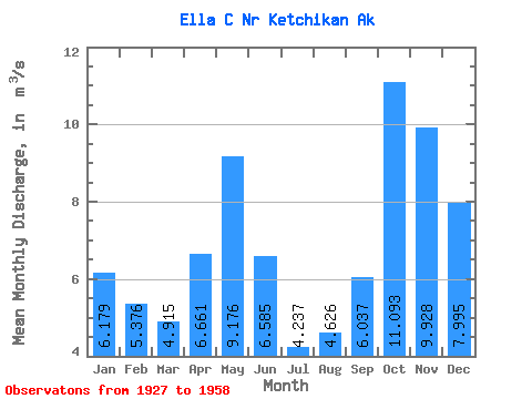
| Statistic | Jan | Feb | Mar | Apr | May | Jun | Jul | Aug | Sep | Oct | Nov | Dec | Annual |
|---|---|---|---|---|---|---|---|---|---|---|---|---|---|
| Mean | 6.18 | 5.38 | 4.92 | 6.66 | 9.18 | 6.58 | 4.24 | 4.63 | 6.04 | 11.09 | 9.93 | 8.00 | 6.89 |
| Standard Deviation | 3.80 | 3.65 | 2.17 | 2.44 | 1.89 | 2.68 | 1.39 | 2.44 | 2.80 | 2.98 | 3.82 | 4.33 | 0.86 |
| Min | 0.71 | 1.47 | 1.78 | 2.30 | 5.30 | 1.51 | 2.20 | 1.19 | 1.96 | 5.90 | 4.15 | 2.50 | 5.00 |
| Max | 13.15 | 14.97 | 8.62 | 12.49 | 12.80 | 11.33 | 7.72 | 8.92 | 11.98 | 17.04 | 20.26 | 21.08 | 8.14 |
| Coefficient of Variation | 0.61 | 0.68 | 0.44 | 0.37 | 0.21 | 0.41 | 0.33 | 0.53 | 0.46 | 0.27 | 0.38 | 0.54 | 0.12 |
 Return to R-Arctic Net Home Page