|
|
|||||||||||||||||
| Point ID: 9320 | Downloads | Plots | Site Data | Code: 15076000 |
|
|
|||||||||||||||||
| Download | |
|---|---|
| Site Descriptor Information | Site Time Series Data |
| Link to all available data | |
| View: | Time Series | All |
| Units: | m3/s |
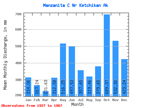
| Statistic | Jan | Feb | Mar | Apr | May | Jun | Jul | Aug | Sep | Oct | Nov | Dec | Annual |
|---|---|---|---|---|---|---|---|---|---|---|---|---|---|
| Mean | 314.01 | 269.54 | 231.59 | 312.56 | 516.17 | 497.54 | 357.60 | 319.42 | 379.64 | 689.26 | 532.32 | 423.17 | 4848.99 |
| Standard Deviation | 143.18 | 164.29 | 85.68 | 115.43 | 119.22 | 136.50 | 113.39 | 137.06 | 175.72 | 209.53 | 148.21 | 223.67 | 599.06 |
| Min | 77.97 | 92.30 | 95.01 | 129.27 | 317.17 | 259.06 | 109.25 | 106.74 | 81.79 | 309.45 | 249.03 | 149.17 | 3496.87 |
| Max | 587.68 | 812.63 | 415.16 | 575.20 | 789.53 | 806.62 | 554.91 | 635.57 | 747.18 | 1237.89 | 786.14 | 1014.98 | 5804.29 |
| Coefficient of Variation | 0.46 | 0.61 | 0.37 | 0.37 | 0.23 | 0.27 | 0.32 | 0.43 | 0.46 | 0.30 | 0.28 | 0.53 | 0.12 |
 Return to R-Arctic Net Home Page