|
|
|||||||||||||||||
| Point ID: 9320 | Downloads | Plots | Site Data | Code: 15076000 |
|
|
|||||||||||||||||
| Download | |
|---|---|
| Site Descriptor Information | Site Time Series Data |
| Link to all available data | |
|
|
| View: | Statistics | Time Series |
| Units: | m3/s |
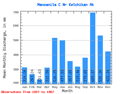
| Statistic | Jan | Feb | Mar | Apr | May | Jun | Jul | Aug | Sep | Oct | Nov | Dec | Annual |
|---|---|---|---|---|---|---|---|---|---|---|---|---|---|
| Mean | 314.01 | 269.54 | 231.59 | 312.56 | 516.17 | 497.54 | 357.60 | 319.42 | 379.64 | 689.26 | 532.32 | 423.17 | 4848.99 |
| Standard Deviation | 143.18 | 164.29 | 85.68 | 115.43 | 119.22 | 136.50 | 113.39 | 137.06 | 175.72 | 209.53 | 148.21 | 223.67 | 599.06 |
| Min | 77.97 | 92.30 | 95.01 | 129.27 | 317.17 | 259.06 | 109.25 | 106.74 | 81.79 | 309.45 | 249.03 | 149.17 | 3496.87 |
| Max | 587.68 | 812.63 | 415.16 | 575.20 | 789.53 | 806.62 | 554.91 | 635.57 | 747.18 | 1237.89 | 786.14 | 1014.98 | 5804.29 |
| Coefficient of Variation | 0.46 | 0.61 | 0.37 | 0.37 | 0.23 | 0.27 | 0.32 | 0.43 | 0.46 | 0.30 | 0.28 | 0.53 | 0.12 |
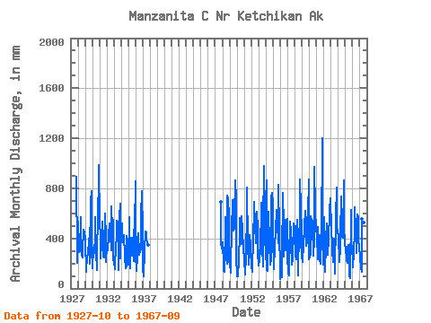
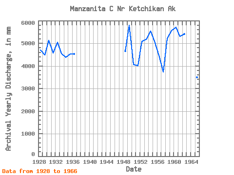
| Year | Jan | Feb | Mar | Apr | May | Jun | Jul | Aug | Sep | Oct | Nov | Dec | Annual | 1927 | 924.29 | 249.03 | 213.31 | 1928 | 549.84 | 273.53 | 415.16 | 296.21 | 587.53 | 378.41 | 273.84 | 257.46 | 302.84 | 482.47 | 424.47 | 470.41 | 4699.61 | 1929 | 399.42 | 124.70 | 265.13 | 201.55 | 334.90 | 329.10 | 329.87 | 503.54 | 194.53 | 716.56 | 779.25 | 330.99 | 4489.68 | 1930 | 166.22 | 307.89 | 252.06 | 305.12 | 410.53 | 573.13 | 296.81 | 149.84 | 201.77 | 675.80 | 786.14 | 1014.98 | 5138.44 | 1931 | 548.50 | 380.28 | 250.92 | 401.26 | 553.13 | 338.68 | 265.91 | 256.38 | 329.64 | 621.58 | 407.45 | 214.89 | 4571.28 | 1932 | 359.04 | 286.23 | 315.22 | 417.97 | 538.14 | 432.19 | 451.11 | 317.22 | 654.14 | 486.37 | 546.99 | 236.23 | 5044.75 | 1933 | 222.72 | 146.68 | 198.51 | 321.85 | 440.48 | 543.31 | 542.49 | 492.31 | 147.51 | 582.64 | 675.43 | 244.82 | 4546.09 | 1934 | 511.14 | 490.74 | 384.62 | 394.72 | 428.12 | 429.01 | 265.12 | 165.75 | 182.43 | 432.18 | 386.11 | 299.01 | 4383.02 | 1935 | 192.94 | 539.47 | 166.16 | 159.67 | 421.26 | 402.40 | 267.83 | 323.52 | 218.66 | 460.49 | 491.40 | 883.28 | 4539.08 | 1936 | 286.02 | 128.60 | 269.22 | 388.17 | 458.98 | 278.96 | 275.27 | 304.71 | 311.90 | 602.83 | 774.21 | 463.25 | 4530.15 | 1937 | 156.38 | 94.43 | 316.22 | 303.73 | 470.96 | 439.38 | 398.31 | 381.25 | 345.73 | 1947 | 716.59 | 360.74 | 328.76 | 1948 | 378.69 | 172.83 | 144.38 | 131.86 | 536.19 | 569.79 | 253.40 | 202.19 | 739.66 | 737.07 | 568.48 | 216.57 | 4649.77 | 1949 | 210.22 | 115.90 | 207.12 | 452.56 | 731.36 | 703.68 | 479.23 | 491.92 | 560.57 | 894.76 | 711.15 | 259.89 | 5804.29 | 1950 | 98.60 | 92.30 | 143.96 | 192.58 | 495.90 | 561.35 | 417.71 | 366.74 | 574.34 | 485.04 | 297.10 | 335.09 | 4049.72 | 1951 | 231.25 | 101.85 | 132.00 | 241.84 | 651.17 | 806.62 | 361.56 | 203.69 | 187.90 | 439.87 | 341.71 | 336.20 | 4024.51 | 1952 | 164.24 | 226.42 | 138.97 | 416.25 | 635.23 | 693.93 | 525.35 | 373.06 | 510.38 | 630.92 | 472.01 | 300.60 | 5086.05 | 1953 | 187.93 | 216.47 | 314.56 | 277.65 | 710.24 | 410.43 | 343.84 | 178.87 | 497.01 | 1013.12 | 582.97 | 465.09 | 5183.31 | 1954 | 242.28 | 812.63 | 152.71 | 142.78 | 516.21 | 611.14 | 377.21 | 193.78 | 238.83 | 753.76 | 760.44 | 707.87 | 5545.86 | 1955 | 310.26 | 255.89 | 159.65 | 343.94 | 471.99 | 630.23 | 462.49 | 635.57 | 363.42 | 857.51 | 458.50 | 149.17 | 5090.27 | 1956 | 77.97 | 133.78 | 95.01 | 241.29 | 789.53 | 489.93 | 261.73 | 403.65 | 302.95 | 563.55 | 551.01 | 574.30 | 4468.79 | 1957 | 277.67 | 110.99 | 108.55 | 235.60 | 552.13 | 451.98 | 377.51 | 199.76 | 237.86 | 309.45 | 516.23 | 366.43 | 3734.65 | 1958 | 514.48 | 255.14 | 241.31 | 447.63 | 565.00 | 259.06 | 109.25 | 493.81 | 323.63 | 899.05 | 651.58 | 465.17 | 5210.72 | 1959 | 271.79 | 198.03 | 370.14 | 337.00 | 513.40 | 621.90 | 488.54 | 354.95 | 371.64 | 572.99 | 594.00 | 897.58 | 5573.41 | 1960 | 242.92 | 230.76 | 296.03 | 575.20 | 551.88 | 539.19 | 518.86 | 266.72 | 388.39 | 1006.71 | 630.90 | 487.10 | 5723.48 | 1961 | 486.40 | 403.84 | 239.69 | 488.03 | 383.95 | 428.82 | 240.59 | 206.42 | 414.83 | 1237.89 | 566.98 | 196.70 | 5299.81 | 1962 | 587.68 | 411.31 | 134.77 | 346.64 | 412.46 | 520.33 | 322.88 | 278.22 | 400.51 | 618.02 | 630.29 | 743.75 | 5411.19 | 1963 | 481.11 | 490.35 | 306.36 | 208.51 | 317.17 | 395.13 | 272.83 | 125.15 | 559.53 | 833.33 | 467.92 | 488.30 | 4957.15 | 1964 | 415.36 | 394.55 | 220.88 | 325.63 | 432.46 | 732.33 | 554.91 | 427.03 | 406.61 | 895.71 | 499.99 | 370.36 | 5675.89 | 1965 | 322.94 | 305.53 | 236.60 | 204.50 | 333.83 | 349.49 | 216.07 | 106.74 | 81.79 | 646.07 | 372.31 | 321.60 | 3496.87 | 1966 | 236.46 | 161.30 | 298.42 | 447.82 | 669.11 | 467.69 | 292.26 | 377.04 | 593.20 | 581.18 | 414.66 | 313.47 | 4843.76 | 1967 | 289.95 | 223.69 | 173.43 | 129.27 | 571.82 | 538.69 | 485.27 | 545.30 | 747.18 |
|---|
 Return to R-Arctic Net Home Page