|
|
|||||||||||||||||
| Point ID: 9320 | Downloads | Plots | Site Data | Code: 15076000 |
|
|
|||||||||||||||||
| Download | |
|---|---|
| Site Descriptor Information | Site Time Series Data |
| Link to all available data | |
| View: | Time Series | All |
| Units: | mm |
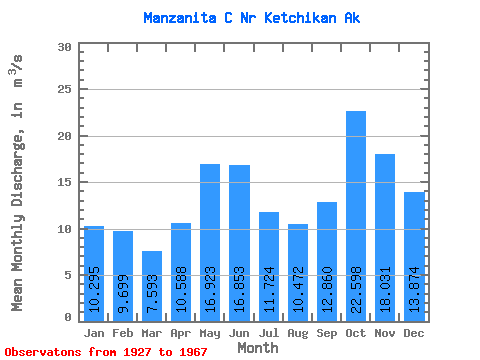
| Statistic | Jan | Feb | Mar | Apr | May | Jun | Jul | Aug | Sep | Oct | Nov | Dec | Annual |
|---|---|---|---|---|---|---|---|---|---|---|---|---|---|
| Mean | 10.29 | 9.70 | 7.59 | 10.59 | 16.92 | 16.85 | 11.72 | 10.47 | 12.86 | 22.60 | 18.03 | 13.87 | 13.49 |
| Standard Deviation | 4.69 | 5.91 | 2.81 | 3.91 | 3.91 | 4.62 | 3.72 | 4.49 | 5.95 | 6.87 | 5.02 | 7.33 | 1.67 |
| Min | 2.56 | 3.32 | 3.12 | 4.38 | 10.40 | 8.78 | 3.58 | 3.50 | 2.77 | 10.15 | 8.44 | 4.89 | 9.73 |
| Max | 19.27 | 29.24 | 13.61 | 19.48 | 25.89 | 27.32 | 18.19 | 20.84 | 25.31 | 40.59 | 26.63 | 33.28 | 16.15 |
| Coefficient of Variation | 0.46 | 0.61 | 0.37 | 0.37 | 0.23 | 0.27 | 0.32 | 0.43 | 0.46 | 0.30 | 0.28 | 0.53 | 0.12 |
 Return to R-Arctic Net Home Page