|
|
|||||||||||||||||
| Point ID: 9299 | Downloads | Plots | Site Data | Code: 15083500 |
|
|
|||||||||||||||||
| Download | |
|---|---|
| Site Descriptor Information | Site Time Series Data |
| Link to all available data | |
| View: | Time Series | All |
| Units: | m3/s |
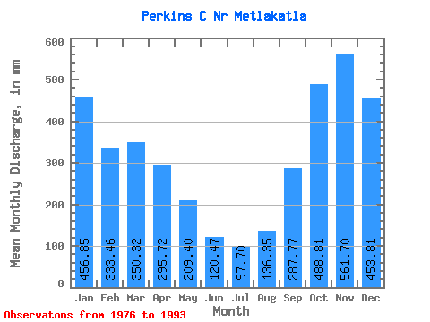
| Statistic | Jan | Feb | Mar | Apr | May | Jun | Jul | Aug | Sep | Oct | Nov | Dec | Annual |
|---|---|---|---|---|---|---|---|---|---|---|---|---|---|
| Mean | 456.72 | 336.27 | 350.12 | 295.80 | 209.43 | 120.36 | 97.61 | 136.28 | 287.71 | 488.75 | 561.70 | 453.81 | 3816.60 |
| Standard Deviation | 173.26 | 141.81 | 137.94 | 100.38 | 94.36 | 78.22 | 57.21 | 123.26 | 147.10 | 132.11 | 266.72 | 218.50 | 714.34 |
| Min | 205.86 | 90.32 | 172.10 | 174.46 | 43.57 | 27.21 | 31.34 | 27.29 | 118.55 | 316.90 | 163.73 | 126.17 | 2967.79 |
| Max | 711.87 | 593.19 | 608.28 | 486.80 | 397.38 | 295.19 | 216.98 | 465.82 | 565.76 | 738.27 | 1062.86 | 942.35 | 5072.84 |
| Coefficient of Variation | 0.38 | 0.42 | 0.39 | 0.34 | 0.45 | 0.65 | 0.59 | 0.90 | 0.51 | 0.27 | 0.47 | 0.48 | 0.19 |
 Return to R-Arctic Net Home Page