|
|
|||||||||||||||||
| Point ID: 9299 | Downloads | Plots | Site Data | Code: 15083500 |
|
|
|||||||||||||||||
| Download | |
|---|---|
| Site Descriptor Information | Site Time Series Data |
| Link to all available data | |
|
|
| View: | Statistics | Time Series |
| Units: | m3/s |
| Statistic | Jan | Feb | Mar | Apr | May | Jun | Jul | Aug | Sep | Oct | Nov | Dec | Annual |
|---|---|---|---|---|---|---|---|---|---|---|---|---|---|
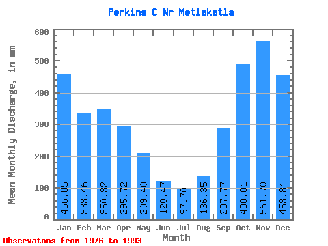
| Mean | 456.72 | 336.27 | 350.12 | 295.80 | 209.43 | 120.36 | 97.61 | 136.28 | 287.71 | 488.75 | 561.70 | 453.81 | 3816.60 |
| Standard Deviation | 173.26 | 141.81 | 137.94 | 100.38 | 94.36 | 78.22 | 57.21 | 123.26 | 147.10 | 132.11 | 266.72 | 218.50 | 714.34 |
| Min | 205.86 | 90.32 | 172.10 | 174.46 | 43.57 | 27.21 | 31.34 | 27.29 | 118.55 | 316.90 | 163.73 | 126.17 | 2967.79 |
| Max | 711.87 | 593.19 | 608.28 | 486.80 | 397.38 | 295.19 | 216.98 | 465.82 | 565.76 | 738.27 | 1062.86 | 942.35 | 5072.84 |
| Coefficient of Variation | 0.38 | 0.42 | 0.39 | 0.34 | 0.45 | 0.65 | 0.59 | 0.90 | 0.51 | 0.27 | 0.47 | 0.48 | 0.19 |
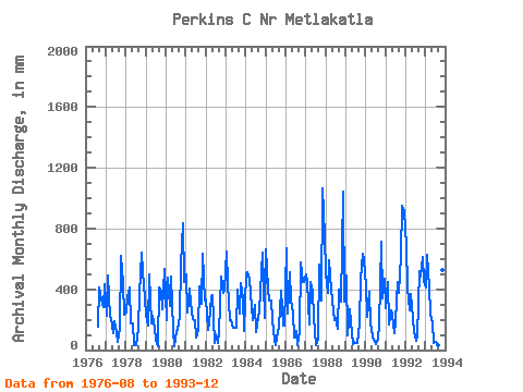
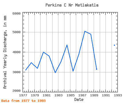
| Year | Jan | Feb | Mar | Apr | May | Jun | Jul | Aug | Sep | Oct | Nov | Dec | Annual | 1976 | 162.25 | 412.31 | 341.96 | 280.88 | 448.30 | 1977 | 233.83 | 460.15 | 227.44 | 213.61 | 114.39 | 192.77 | 123.86 | 55.46 | 138.00 | 641.38 | 443.15 | 240.97 | 3106.10 | 1978 | 255.38 | 324.61 | 429.41 | 177.07 | 179.84 | 31.77 | 31.34 | 147.90 | 368.89 | 666.05 | 509.82 | 349.11 | 3475.55 | 1979 | 242.98 | 150.38 | 512.59 | 174.46 | 234.05 | 143.20 | 71.82 | 27.29 | 410.57 | 400.28 | 272.16 | 551.23 | 3180.88 | 1980 | 205.86 | 449.53 | 303.20 | 486.80 | 135.45 | 27.21 | 127.51 | 139.04 | 224.33 | 581.04 | 834.60 | 463.08 | 4000.55 | 1981 | 513.89 | 231.04 | 419.32 | 312.39 | 209.07 | 194.63 | 83.69 | 134.43 | 418.20 | 316.90 | 634.73 | 336.84 | 3809.79 | 1982 | 343.95 | 123.82 | 179.13 | 353.60 | 372.47 | 45.26 | 109.25 | 45.34 | 119.27 | 498.99 | 377.73 | 411.40 | 2967.79 | 1983 | 672.22 | 414.44 | 204.14 | 196.56 | 152.94 | 146.63 | 153.68 | 412.62 | 238.14 | 454.50 | 344.00 | 126.17 | 3523.03 | 1984 | 523.65 | 481.90 | 483.59 | 366.79 | 204.54 | 295.19 | 121.73 | 227.31 | 253.93 | 529.19 | 640.17 | 220.36 | 4367.20 | 1985 | 685.94 | 381.32 | 337.95 | 324.68 | 203.14 | 70.62 | 31.65 | 119.47 | 151.40 | 402.93 | 163.73 | 169.87 | 3047.89 | 1986 | 692.23 | 225.87 | 529.55 | 332.82 | 249.48 | 84.16 | 132.38 | 35.06 | 123.87 | 596.79 | 445.85 | 461.80 | 3893.55 | 1987 | 515.77 | 422.82 | 177.43 | 445.74 | 397.38 | 221.11 | 35.30 | 74.47 | 565.76 | 335.42 | 1062.86 | 777.07 | 5056.19 | 1988 | 518.89 | 355.44 | 608.28 | 400.72 | 335.73 | 196.56 | 216.98 | 146.27 | 399.71 | 331.75 | 1042.01 | 330.75 | 4896.14 | 1989 | 507.38 | 90.32 | 274.17 | 189.28 | 43.57 | 52.12 | 51.43 | 50.86 | 172.79 | 475.06 | 636.39 | 612.68 | 3142.27 | 1990 | 432.84 | 205.16 | 397.39 | 179.06 | 90.50 | 67.33 | 43.82 | 80.19 | 163.38 | 738.27 | 336.96 | 482.35 | 3203.60 | 1991 | 283.84 | 421.18 | 172.10 | 260.07 | 243.40 | 114.68 | 199.94 | 465.82 | 379.00 | 637.48 | 948.04 | 942.35 | 5072.84 | 1992 | 711.87 | 385.40 | 268.06 | 372.39 | 215.31 | 119.71 | 66.34 | 98.90 | 520.79 | 501.11 | 611.35 | 469.31 | 4352.47 | 1993 | 423.65 | 593.19 | 428.30 | 242.47 | 178.98 | 43.18 | 58.73 | 30.33 | 118.55 | 348.37 | 526.07 | 774.92 | 3786.32 |
|---|
 Return to R-Arctic Net Home Page