|
|
|||||||||||||||||
| Point ID: 9299 | Downloads | Plots | Site Data | Code: 15083500 |
|
|
|||||||||||||||||
| Download | |
|---|---|
| Site Descriptor Information | Site Time Series Data |
| Link to all available data | |
| View: | Time Series | All |
| Units: | mm |
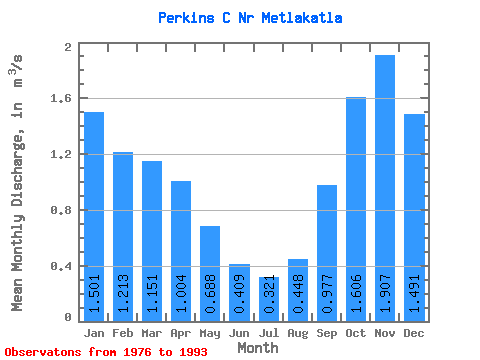
| Statistic | Jan | Feb | Mar | Apr | May | Jun | Jul | Aug | Sep | Oct | Nov | Dec | Annual |
|---|---|---|---|---|---|---|---|---|---|---|---|---|---|
| Mean | 1.50 | 1.21 | 1.15 | 1.00 | 0.69 | 0.41 | 0.32 | 0.45 | 0.98 | 1.61 | 1.91 | 1.49 | 1.06 |
| Standard Deviation | 0.57 | 0.51 | 0.45 | 0.34 | 0.31 | 0.27 | 0.19 | 0.41 | 0.50 | 0.43 | 0.91 | 0.72 | 0.20 |
| Min | 0.68 | 0.33 | 0.57 | 0.59 | 0.14 | 0.09 | 0.10 | 0.09 | 0.40 | 1.04 | 0.56 | 0.41 | 0.83 |
| Max | 2.34 | 2.14 | 2.00 | 1.65 | 1.31 | 1.00 | 0.71 | 1.53 | 1.92 | 2.43 | 3.61 | 3.10 | 1.41 |
| Coefficient of Variation | 0.38 | 0.42 | 0.39 | 0.34 | 0.45 | 0.65 | 0.59 | 0.90 | 0.51 | 0.27 | 0.47 | 0.48 | 0.19 |
 Return to R-Arctic Net Home Page