|
|
|||||||||||||||||
| Point ID: 9278 | Downloads | Plots | Site Data | Code: 15024750 |
|
|
|||||||||||||||||
| Download | |
|---|---|
| Site Descriptor Information | Site Time Series Data |
| Link to all available data | |
| View: | Time Series | All |
| Units: | m3/s |
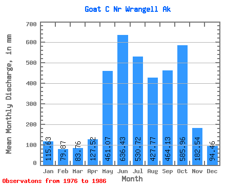
| Statistic | Jan | Feb | Mar | Apr | May | Jun | Jul | Aug | Sep | Oct | Nov | Dec | Annual |
|---|---|---|---|---|---|---|---|---|---|---|---|---|---|
| Mean | 115.62 | 80.56 | 83.77 | 127.50 | 460.98 | 636.43 | 530.62 | 427.68 | 464.15 | 585.89 | 182.56 | 94.44 | 3737.40 |
| Standard Deviation | 91.75 | 41.56 | 53.55 | 43.81 | 134.05 | 80.30 | 122.15 | 124.20 | 383.84 | 362.97 | 117.51 | 56.01 | 660.37 |
| Min | 36.91 | 11.11 | 19.02 | 43.85 | 241.40 | 490.62 | 378.33 | 252.10 | 244.38 | 304.41 | 65.04 | 27.79 | 2846.09 |
| Max | 289.83 | 134.07 | 194.87 | 179.13 | 696.90 | 765.21 | 762.09 | 658.12 | 1585.36 | 1486.13 | 341.48 | 181.61 | 4797.60 |
| Coefficient of Variation | 0.79 | 0.52 | 0.64 | 0.34 | 0.29 | 0.13 | 0.23 | 0.29 | 0.83 | 0.62 | 0.64 | 0.59 | 0.18 |
 Return to R-Arctic Net Home Page