|
|
|||||||||||||||||
| Point ID: 9278 | Downloads | Plots | Site Data | Code: 15024750 |
|
|
|||||||||||||||||
| Download | |
|---|---|
| Site Descriptor Information | Site Time Series Data |
| Link to all available data | |
| View: | Time Series | All |
| Units: | mm |
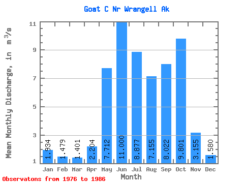
| Statistic | Jan | Feb | Mar | Apr | May | Jun | Jul | Aug | Sep | Oct | Nov | Dec | Annual |
|---|---|---|---|---|---|---|---|---|---|---|---|---|---|
| Mean | 1.93 | 1.48 | 1.40 | 2.20 | 7.71 | 11.00 | 8.88 | 7.16 | 8.02 | 9.80 | 3.15 | 1.58 | 5.30 |
| Standard Deviation | 1.54 | 0.76 | 0.90 | 0.76 | 2.24 | 1.39 | 2.04 | 2.08 | 6.63 | 6.07 | 2.03 | 0.94 | 0.94 |
| Min | 0.62 | 0.20 | 0.32 | 0.76 | 4.04 | 8.48 | 6.33 | 4.22 | 4.22 | 5.09 | 1.12 | 0.47 | 4.04 |
| Max | 4.85 | 2.46 | 3.26 | 3.10 | 11.66 | 13.23 | 12.75 | 11.01 | 27.40 | 24.86 | 5.90 | 3.04 | 6.81 |
| Coefficient of Variation | 0.79 | 0.52 | 0.64 | 0.34 | 0.29 | 0.13 | 0.23 | 0.29 | 0.83 | 0.62 | 0.64 | 0.59 | 0.18 |
 Return to R-Arctic Net Home Page