|
|
|||||||||||||||||
| Point ID: 9278 | Downloads | Plots | Site Data | Code: 15024750 |
|
|
|||||||||||||||||
| Download | |
|---|---|
| Site Descriptor Information | Site Time Series Data |
| Link to all available data | |
|
|
| View: | Statistics | Time Series |
| Units: | m3/s |
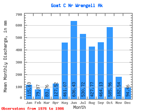
| Statistic | Jan | Feb | Mar | Apr | May | Jun | Jul | Aug | Sep | Oct | Nov | Dec | Annual |
|---|---|---|---|---|---|---|---|---|---|---|---|---|---|
| Mean | 115.62 | 80.56 | 83.77 | 127.50 | 460.98 | 636.43 | 530.62 | 427.68 | 464.15 | 585.89 | 182.56 | 94.44 | 3737.40 |
| Standard Deviation | 91.75 | 41.56 | 53.55 | 43.81 | 134.05 | 80.30 | 122.15 | 124.20 | 383.84 | 362.97 | 117.51 | 56.01 | 660.37 |
| Min | 36.91 | 11.11 | 19.02 | 43.85 | 241.40 | 490.62 | 378.33 | 252.10 | 244.38 | 304.41 | 65.04 | 27.79 | 2846.09 |
| Max | 289.83 | 134.07 | 194.87 | 179.13 | 696.90 | 765.21 | 762.09 | 658.12 | 1585.36 | 1486.13 | 341.48 | 181.61 | 4797.60 |
| Coefficient of Variation | 0.79 | 0.52 | 0.64 | 0.34 | 0.29 | 0.13 | 0.23 | 0.29 | 0.83 | 0.62 | 0.64 | 0.59 | 0.18 |
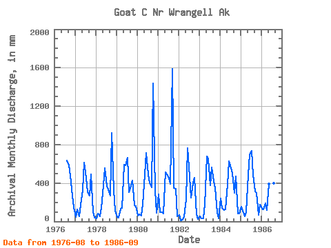
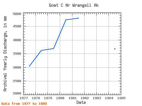
| Year | Jan | Feb | Mar | Apr | May | Jun | Jul | Aug | Sep | Oct | Nov | Dec | Annual | 1976 | 658.12 | 583.35 | 492.41 | 260.39 | 149.62 | 1977 | 46.14 | 119.86 | 54.50 | 173.12 | 339.52 | 614.32 | 473.97 | 314.40 | 267.53 | 506.00 | 93.88 | 42.37 | 3039.92 | 1978 | 36.91 | 79.65 | 57.55 | 137.40 | 387.08 | 555.44 | 378.33 | 342.53 | 271.90 | 953.10 | 325.65 | 111.22 | 3621.27 | 1979 | 46.79 | 40.26 | 136.29 | 136.85 | 610.95 | 586.58 | 681.40 | 315.93 | 372.23 | 444.03 | 169.62 | 163.16 | 3682.77 | 1980 | 60.01 | 70.15 | 64.27 | 175.85 | 507.10 | 713.00 | 510.49 | 408.05 | 354.97 | 1486.13 | 324.12 | 95.34 | 4741.80 | 1981 | 289.83 | 94.46 | 100.36 | 81.05 | 527.19 | 490.62 | 467.27 | 402.37 | 1585.36 | 360.27 | 341.48 | 52.76 | 4797.60 | 1982 | 72.92 | 11.11 | 19.02 | 43.85 | 241.40 | 765.21 | 477.80 | 252.10 | 400.24 | 469.64 | 73.29 | 27.79 | 2846.09 | 1983 | 52.31 | 32.00 | 36.04 | 179.13 | 696.90 | 646.87 | 392.14 | 582.01 | 417.50 | 360.22 | 91.09 | 34.18 | 3503.85 | 1984 | 249.92 | 134.07 | 119.09 | 128.28 | 395.38 | 628.73 | 577.68 | 514.86 | 294.02 | 482.69 | 81.04 | 86.33 | 3675.67 | 1985 | 161.63 | 107.08 | 55.69 | 99.39 | 497.87 | 697.76 | 762.09 | 499.40 | 314.18 | 304.41 | 65.04 | 181.61 | 3727.60 | 1986 | 139.72 | 117.00 | 194.87 | 120.09 | 406.40 | 665.76 | 585.03 | 414.65 | 244.38 |
|---|
 Return to R-Arctic Net Home Page