|
|
|||||||||||||||||
| Point ID: 9239 | Downloads | Plots | Site Data | Code: 15036000 |
|
|
|||||||||||||||||
| Download | |
|---|---|
| Site Descriptor Information | Site Time Series Data |
| Link to all available data | |
| View: | Time Series | All |
| Units: | m3/s |
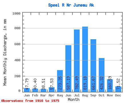
| Statistic | Jan | Feb | Mar | Apr | May | Jun | Jul | Aug | Sep | Oct | Nov | Dec | Annual |
|---|---|---|---|---|---|---|---|---|---|---|---|---|---|
| Mean | 47.78 | 40.75 | 38.50 | 57.53 | 273.31 | 587.19 | 782.37 | 819.06 | 661.67 | 426.26 | 160.59 | 71.51 | 3919.56 |
| Standard Deviation | 37.23 | 28.75 | 28.27 | 23.49 | 97.55 | 142.99 | 115.21 | 176.20 | 148.46 | 144.01 | 100.58 | 48.55 | 555.43 |
| Min | 8.92 | 5.41 | 8.21 | 22.90 | 182.39 | 417.59 | 633.18 | 513.69 | 316.01 | 169.56 | 39.79 | 12.62 | 3048.72 |
| Max | 129.77 | 110.50 | 124.42 | 111.77 | 512.85 | 878.56 | 1099.77 | 1289.31 | 896.91 | 743.18 | 444.97 | 167.66 | 5329.11 |
| Coefficient of Variation | 0.78 | 0.70 | 0.73 | 0.41 | 0.36 | 0.24 | 0.15 | 0.21 | 0.22 | 0.34 | 0.63 | 0.68 | 0.14 |
 Return to R-Arctic Net Home Page