|
|
|||||||||||||||||
| Point ID: 9239 | Downloads | Plots | Site Data | Code: 15036000 |
|
|
|||||||||||||||||
| Download | |
|---|---|
| Site Descriptor Information | Site Time Series Data |
| Link to all available data | |
|
|
| View: | Statistics | Time Series |
| Units: | m3/s |
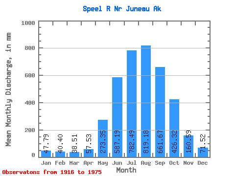
| Statistic | Jan | Feb | Mar | Apr | May | Jun | Jul | Aug | Sep | Oct | Nov | Dec | Annual |
|---|---|---|---|---|---|---|---|---|---|---|---|---|---|
| Mean | 47.78 | 40.75 | 38.50 | 57.53 | 273.31 | 587.19 | 782.37 | 819.06 | 661.67 | 426.26 | 160.59 | 71.51 | 3919.56 |
| Standard Deviation | 37.23 | 28.75 | 28.27 | 23.49 | 97.55 | 142.99 | 115.21 | 176.20 | 148.46 | 144.01 | 100.58 | 48.55 | 555.43 |
| Min | 8.92 | 5.41 | 8.21 | 22.90 | 182.39 | 417.59 | 633.18 | 513.69 | 316.01 | 169.56 | 39.79 | 12.62 | 3048.72 |
| Max | 129.77 | 110.50 | 124.42 | 111.77 | 512.85 | 878.56 | 1099.77 | 1289.31 | 896.91 | 743.18 | 444.97 | 167.66 | 5329.11 |
| Coefficient of Variation | 0.78 | 0.70 | 0.73 | 0.41 | 0.36 | 0.24 | 0.15 | 0.21 | 0.22 | 0.34 | 0.63 | 0.68 | 0.14 |
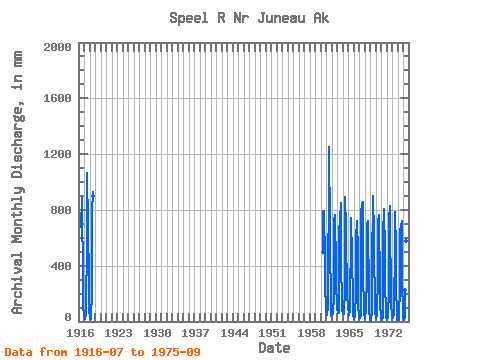
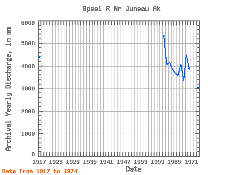
| Year | Jan | Feb | Mar | Apr | May | Jun | Jul | Aug | Sep | Oct | Nov | Dec | Annual | 1916 | 702.64 | 913.04 | 780.00 | 374.43 | 95.33 | 54.42 | 1917 | 46.08 | 59.02 | 22.00 | 43.56 | 219.92 | 447.89 | 734.74 | 1101.27 | 683.27 | 547.50 | 444.97 | 64.78 | 4394.31 | 1918 | 48.92 | 20.70 | 17.93 | 44.75 | 203.39 | 496.93 | 813.81 | 961.35 | 896.91 | 1960 | 512.85 | 509.34 | 818.87 | 817.08 | 701.74 | 533.42 | 200.46 | 167.66 | 1961 | 71.33 | 65.43 | 48.61 | 111.77 | 450.46 | 824.60 | 1099.77 | 1289.31 | 660.95 | 591.43 | 107.75 | 42.03 | 5329.11 | 1962 | 129.77 | 60.29 | 55.70 | 52.38 | 197.56 | 537.05 | 768.47 | 726.93 | 761.14 | 397.09 | 234.12 | 149.31 | 4054.27 | 1963 | 85.14 | 110.50 | 62.06 | 61.66 | 221.51 | 580.65 | 808.72 | 695.91 | 849.34 | 490.75 | 75.92 | 143.06 | 4171.86 | 1964 | 86.64 | 73.07 | 54.27 | 96.85 | 212.94 | 735.69 | 920.31 | 684.17 | 316.01 | 425.17 | 168.97 | 127.94 | 3882.01 | 1965 | 117.65 | 42.04 | 55.65 | 71.17 | 190.41 | 574.75 | 764.50 | 748.87 | 472.76 | 531.20 | 96.45 | 57.15 | 3699.51 | 1966 | 22.19 | 18.17 | 35.65 | 85.28 | 182.39 | 489.23 | 646.55 | 709.33 | 723.15 | 504.04 | 125.78 | 27.67 | 3553.57 | 1967 | 26.79 | 23.78 | 22.65 | 38.82 | 263.56 | 809.46 | 679.90 | 870.32 | 855.90 | 258.59 | 184.13 | 54.44 | 4078.88 | 1968 | 26.90 | 68.75 | 124.42 | 60.44 | 360.11 | 478.03 | 733.20 | 513.69 | 716.88 | 169.56 | 64.50 | 37.11 | 3343.07 | 1969 | 8.92 | 5.41 | 16.17 | 66.51 | 403.51 | 878.56 | 860.88 | 929.38 | 611.50 | 364.51 | 276.32 | 86.63 | 4487.73 | 1970 | 20.56 | 43.46 | 43.76 | 57.48 | 338.40 | 704.96 | 726.46 | 785.10 | 664.67 | 353.10 | 143.31 | 19.17 | 3885.86 | 1971 | 30.65 | 30.62 | 11.89 | 35.02 | 214.95 | 631.27 | 821.09 | 834.54 | 500.35 | 270.71 | 85.63 | 31.02 | 3478.80 | 1972 | 13.54 | 11.81 | 34.02 | 22.90 | 246.45 | 465.07 | 748.20 | 854.56 | 493.87 | 426.08 | 127.91 | 45.51 | 3464.67 | 1973 | 33.85 | 38.15 | 29.46 | 55.05 | 221.09 | 417.59 | 633.18 | 807.54 | 512.64 | 265.65 | 39.79 | 12.62 | 3048.72 | 1974 | 9.20 | 9.42 | 12.11 | 38.93 | 249.44 | 483.55 | 648.31 | 725.54 | 670.06 | 743.18 | 258.72 | 95.13 | 3921.10 | 1975 | 34.21 | 12.14 | 8.21 | 35.46 | 230.63 | 504.87 | 935.48 | 594.14 | 700.58 |
|---|
 Return to R-Arctic Net Home Page