|
|
|||||||||||||||||
| Point ID: 9239 | Downloads | Plots | Site Data | Code: 15036000 |
|
|
|||||||||||||||||
| Download | |
|---|---|
| Site Descriptor Information | Site Time Series Data |
| Link to all available data | |
| View: | Time Series | All |
| Units: | mm |
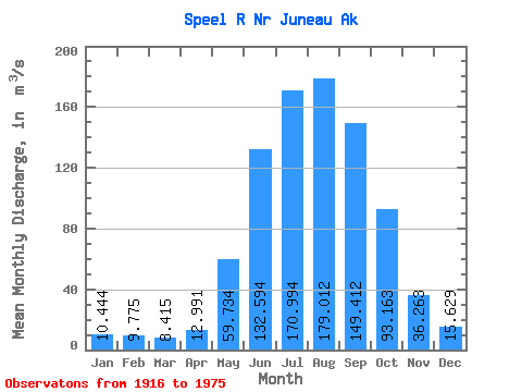
| Statistic | Jan | Feb | Mar | Apr | May | Jun | Jul | Aug | Sep | Oct | Nov | Dec | Annual |
|---|---|---|---|---|---|---|---|---|---|---|---|---|---|
| Mean | 10.44 | 9.78 | 8.41 | 12.99 | 59.73 | 132.59 | 170.99 | 179.01 | 149.41 | 93.16 | 36.26 | 15.63 | 72.69 |
| Standard Deviation | 8.14 | 6.90 | 6.18 | 5.30 | 21.32 | 32.29 | 25.18 | 38.51 | 33.52 | 31.48 | 22.71 | 10.61 | 10.30 |
| Min | 1.95 | 1.30 | 1.79 | 5.17 | 39.86 | 94.30 | 138.39 | 112.27 | 71.36 | 37.06 | 8.99 | 2.76 | 56.54 |
| Max | 28.36 | 26.51 | 27.19 | 25.24 | 112.09 | 198.39 | 240.36 | 281.79 | 202.53 | 162.43 | 100.48 | 36.64 | 98.83 |
| Coefficient of Variation | 0.78 | 0.70 | 0.73 | 0.41 | 0.36 | 0.24 | 0.15 | 0.21 | 0.22 | 0.34 | 0.63 | 0.68 | 0.14 |
 Return to R-Arctic Net Home Page