|
|
|||||||||||||||||
| Point ID: 9208 | Downloads | Plots | Site Data | Code: 15238820 |
|
|
|||||||||||||||||
| Download | |
|---|---|
| Site Descriptor Information | Site Time Series Data |
| Link to all available data | |
| View: | Time Series | All |
| Units: | m3/s |
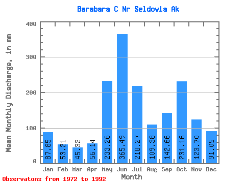
| Statistic | Jan | Feb | Mar | Apr | May | Jun | Jul | Aug | Sep | Oct | Nov | Dec | Annual |
|---|---|---|---|---|---|---|---|---|---|---|---|---|---|
| Mean | 87.84 | 53.67 | 45.34 | 56.13 | 233.23 | 365.50 | 218.24 | 109.37 | 142.66 | 231.15 | 123.70 | 91.03 | 1773.01 |
| Standard Deviation | 66.89 | 35.72 | 25.53 | 23.33 | 79.31 | 81.10 | 75.07 | 54.48 | 63.59 | 131.15 | 86.89 | 48.32 | 337.07 |
| Min | 30.57 | 23.03 | 21.90 | 23.74 | 132.35 | 251.74 | 91.18 | 50.07 | 55.73 | 79.82 | 54.87 | 31.30 | 1184.86 |
| Max | 256.04 | 166.02 | 118.39 | 127.12 | 467.06 | 498.94 | 329.75 | 237.41 | 257.48 | 616.44 | 387.12 | 206.06 | 2290.78 |
| Coefficient of Variation | 0.76 | 0.67 | 0.56 | 0.42 | 0.34 | 0.22 | 0.34 | 0.50 | 0.45 | 0.57 | 0.70 | 0.53 | 0.19 |
 Return to R-Arctic Net Home Page