|
|
|||||||||||||||||
| Point ID: 9208 | Downloads | Plots | Site Data | Code: 15238820 |
|
|
|||||||||||||||||
| Download | |
|---|---|
| Site Descriptor Information | Site Time Series Data |
| Link to all available data | |
|
|
| View: | Statistics | Time Series |
| Units: | m3/s |
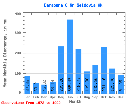
| Statistic | Jan | Feb | Mar | Apr | May | Jun | Jul | Aug | Sep | Oct | Nov | Dec | Annual |
|---|---|---|---|---|---|---|---|---|---|---|---|---|---|
| Mean | 87.84 | 53.67 | 45.34 | 56.13 | 233.23 | 365.50 | 218.24 | 109.37 | 142.66 | 231.15 | 123.70 | 91.03 | 1773.01 |
| Standard Deviation | 66.89 | 35.72 | 25.53 | 23.33 | 79.31 | 81.10 | 75.07 | 54.48 | 63.59 | 131.15 | 86.89 | 48.32 | 337.07 |
| Min | 30.57 | 23.03 | 21.90 | 23.74 | 132.35 | 251.74 | 91.18 | 50.07 | 55.73 | 79.82 | 54.87 | 31.30 | 1184.86 |
| Max | 256.04 | 166.02 | 118.39 | 127.12 | 467.06 | 498.94 | 329.75 | 237.41 | 257.48 | 616.44 | 387.12 | 206.06 | 2290.78 |
| Coefficient of Variation | 0.76 | 0.67 | 0.56 | 0.42 | 0.34 | 0.22 | 0.34 | 0.50 | 0.45 | 0.57 | 0.70 | 0.53 | 0.19 |
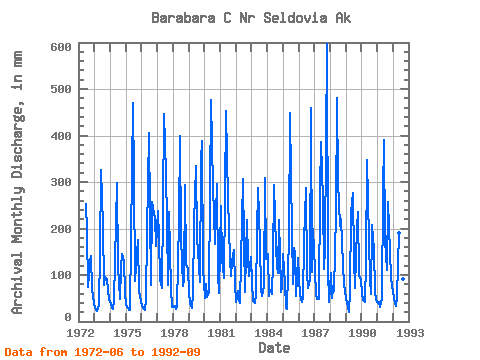
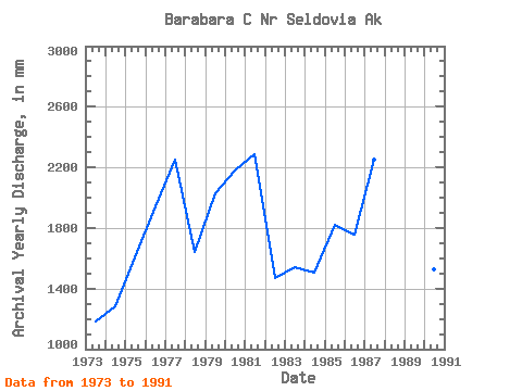
| Year | Jan | Feb | Mar | Apr | May | Jun | Jul | Aug | Sep | Oct | Nov | Dec | Annual | 1972 | 251.74 | 199.65 | 76.90 | 128.72 | 145.17 | 70.30 | 42.23 | 1973 | 30.57 | 23.03 | 22.63 | 36.38 | 152.01 | 325.36 | 211.09 | 80.46 | 95.26 | 94.61 | 65.96 | 49.52 | 1184.86 | 1974 | 38.16 | 26.41 | 27.29 | 47.06 | 220.94 | 296.83 | 121.31 | 50.07 | 114.48 | 150.06 | 129.68 | 65.62 | 1286.51 | 1975 | 36.57 | 27.62 | 24.73 | 23.74 | 182.46 | 469.23 | 317.11 | 90.32 | 146.70 | 182.19 | 66.41 | 45.55 | 1609.36 | 1976 | 34.15 | 26.36 | 25.14 | 47.70 | 199.48 | 405.88 | 242.22 | 80.09 | 257.48 | 238.41 | 221.93 | 168.04 | 1944.90 | 1977 | 245.31 | 166.02 | 93.56 | 72.16 | 259.69 | 446.73 | 329.75 | 220.07 | 78.73 | 243.71 | 69.79 | 31.30 | 2254.01 | 1978 | 31.95 | 31.26 | 26.98 | 33.46 | 226.10 | 398.07 | 187.41 | 77.91 | 90.70 | 304.05 | 123.10 | 117.52 | 1643.00 | 1979 | 63.66 | 38.12 | 30.57 | 59.57 | 219.56 | 334.08 | 186.16 | 156.45 | 85.72 | 356.16 | 387.12 | 118.07 | 2030.64 | 1980 | 53.31 | 75.13 | 54.46 | 63.59 | 289.99 | 475.34 | 299.63 | 237.41 | 167.02 | 305.32 | 100.19 | 63.91 | 2179.59 | 1981 | 256.04 | 127.06 | 118.39 | 93.58 | 467.06 | 353.24 | 274.00 | 139.70 | 98.32 | 132.76 | 153.87 | 82.97 | 2290.78 | 1982 | 43.45 | 61.28 | 46.46 | 39.82 | 133.72 | 306.96 | 175.72 | 65.36 | 217.41 | 136.04 | 98.50 | 142.84 | 1468.71 | 1983 | 86.48 | 42.45 | 41.71 | 60.03 | 197.66 | 287.02 | 171.42 | 69.92 | 55.73 | 79.82 | 309.34 | 139.80 | 1541.01 | 1984 | 148.92 | 51.70 | 70.65 | 59.11 | 132.35 | 292.86 | 166.18 | 123.04 | 104.02 | 226.41 | 63.36 | 74.44 | 1507.80 | 1985 | 151.01 | 74.99 | 29.07 | 27.39 | 186.71 | 449.10 | 321.11 | 82.51 | 158.12 | 149.83 | 54.87 | 140.98 | 1822.62 | 1986 | 97.48 | 53.40 | 43.18 | 50.02 | 177.80 | 286.56 | 108.52 | 75.03 | 90.79 | 474.96 | 105.67 | 206.06 | 1760.24 | 1987 | 115.19 | 53.86 | 49.10 | 49.20 | 290.94 | 386.97 | 270.25 | 115.74 | 158.57 | 616.44 | 112.33 | 43.63 | 2249.91 | 1988 | 107.44 | 47.39 | 70.33 | 65.22 | 242.11 | 481.19 | 312.27 | 211.30 | 221.43 | 175.48 | 78.83 | 69.41 | 2077.19 | 1989 | 50.20 | 29.28 | 21.90 | 66.64 | 243.85 | 275.51 | 137.95 | 73.75 | 201.57 | 243.03 | 100.01 | 91.78 | 1531.76 | 1990 | 60.06 | 43.09 | 44.18 | 127.12 | 359.36 | 262.83 | 91.18 | 60.02 | 208.51 | 158.37 | 66.32 | 47.55 | 1526.99 | 1991 | 41.26 | 39.82 | 32.41 | 48.61 | 286.43 | 391.00 | 181.66 | 115.42 | 257.16 | 210.07 | 96.40 | 79.36 | 1777.34 | 1992 | 65.67 | 35.12 | 34.04 | 52.22 | 196.42 | 498.94 | 278.39 | 95.29 | 59.48 |
|---|
 Return to R-Arctic Net Home Page