|
|
|||||||||||||||||
| Point ID: 9208 | Downloads | Plots | Site Data | Code: 15238820 |
|
|
|||||||||||||||||
| Download | |
|---|---|
| Site Descriptor Information | Site Time Series Data |
| Link to all available data | |
| View: | Time Series | All |
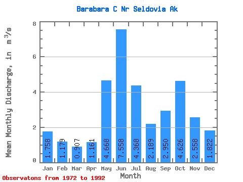
| Units: | mm |
| Statistic | Jan | Feb | Mar | Apr | May | Jun | Jul | Aug | Sep | Oct | Nov | Dec | Annual |
|---|---|---|---|---|---|---|---|---|---|---|---|---|---|
| Mean | 1.76 | 1.18 | 0.91 | 1.16 | 4.67 | 7.56 | 4.37 | 2.19 | 2.95 | 4.63 | 2.56 | 1.82 | 3.01 |
| Standard Deviation | 1.34 | 0.79 | 0.51 | 0.48 | 1.59 | 1.68 | 1.50 | 1.09 | 1.31 | 2.62 | 1.80 | 0.97 | 0.57 |
| Min | 0.61 | 0.51 | 0.44 | 0.49 | 2.65 | 5.21 | 1.82 | 1.00 | 1.15 | 1.60 | 1.14 | 0.63 | 2.01 |
| Max | 5.12 | 3.65 | 2.37 | 2.63 | 9.35 | 10.32 | 6.60 | 4.75 | 5.32 | 12.34 | 8.01 | 4.12 | 3.89 |
| Coefficient of Variation | 0.76 | 0.67 | 0.56 | 0.42 | 0.34 | 0.22 | 0.34 | 0.50 | 0.45 | 0.57 | 0.70 | 0.53 | 0.19 |
 Return to R-Arctic Net Home Page