|
|
|||||||||||||||||
| Point ID: 9203 | Downloads | Plots | Site Data | Code: 15238500 |
|
|
|||||||||||||||||
| Download | |
|---|---|
| Site Descriptor Information | Site Time Series Data |
| Link to all available data | |
| View: | Time Series | All |
| Units: | m3/s |
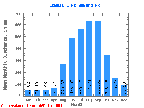
| Statistic | Jan | Feb | Mar | Apr | May | Jun | Jul | Aug | Sep | Oct | Nov | Dec | Annual |
|---|---|---|---|---|---|---|---|---|---|---|---|---|---|
| Mean | 51.92 | 51.68 | 50.38 | 74.75 | 270.61 | 485.02 | 560.39 | 631.72 | 631.58 | 348.40 | 155.69 | 93.20 | 3753.09 |
| Standard Deviation | 22.45 | 33.41 | 26.00 | 33.47 | 114.84 | 153.95 | 133.87 | 217.81 | 352.02 | 94.58 | 60.91 | 44.33 | 118.07 |
| Min | 12.14 | 19.66 | 13.16 | 42.31 | 127.96 | 314.55 | 442.64 | 336.34 | 219.73 | 220.16 | 91.07 | 27.93 | 3638.07 |
| Max | 73.93 | 95.28 | 74.01 | 132.34 | 456.09 | 758.90 | 767.87 | 1010.01 | 1194.13 | 497.27 | 265.12 | 156.39 | 3896.30 |
| Coefficient of Variation | 0.43 | 0.65 | 0.52 | 0.45 | 0.42 | 0.32 | 0.24 | 0.34 | 0.56 | 0.27 | 0.39 | 0.48 | 0.03 |
 Return to R-Arctic Net Home Page