|
|
|||||||||||||||||
| Point ID: 9203 | Downloads | Plots | Site Data | Code: 15238500 |
|
|
|||||||||||||||||
| Download | |
|---|---|
| Site Descriptor Information | Site Time Series Data |
| Link to all available data | |
| View: | Time Series | All |
| Units: | mm |
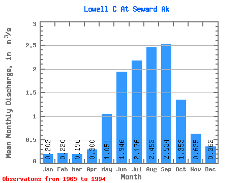
| Statistic | Jan | Feb | Mar | Apr | May | Jun | Jul | Aug | Sep | Oct | Nov | Dec | Annual |
|---|---|---|---|---|---|---|---|---|---|---|---|---|---|
| Mean | 0.20 | 0.22 | 0.20 | 0.30 | 1.05 | 1.95 | 2.18 | 2.45 | 2.53 | 1.35 | 0.62 | 0.36 | 1.24 |
| Standard Deviation | 0.09 | 0.14 | 0.10 | 0.13 | 0.45 | 0.62 | 0.52 | 0.85 | 1.41 | 0.37 | 0.24 | 0.17 | 0.04 |
| Min | 0.05 | 0.08 | 0.05 | 0.17 | 0.50 | 1.26 | 1.72 | 1.31 | 0.88 | 0.85 | 0.36 | 0.11 | 1.20 |
| Max | 0.29 | 0.41 | 0.29 | 0.53 | 1.77 | 3.04 | 2.98 | 3.92 | 4.79 | 1.93 | 1.06 | 0.61 | 1.28 |
| Coefficient of Variation | 0.43 | 0.65 | 0.52 | 0.45 | 0.42 | 0.32 | 0.24 | 0.34 | 0.56 | 0.27 | 0.39 | 0.48 | 0.03 |
 Return to R-Arctic Net Home Page