|
|
|||||||||||||||||
| Point ID: 9203 | Downloads | Plots | Site Data | Code: 15238500 |
|
|
|||||||||||||||||
| Download | |
|---|---|
| Site Descriptor Information | Site Time Series Data |
| Link to all available data | |
|
|
| View: | Statistics | Time Series |
| Units: | m3/s |
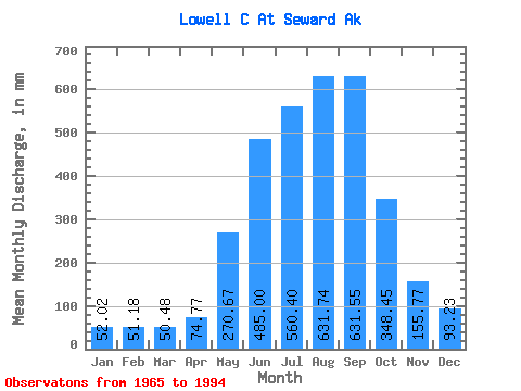
| Statistic | Jan | Feb | Mar | Apr | May | Jun | Jul | Aug | Sep | Oct | Nov | Dec | Annual |
|---|---|---|---|---|---|---|---|---|---|---|---|---|---|
| Mean | 51.92 | 51.68 | 50.38 | 74.75 | 270.61 | 485.02 | 560.39 | 631.72 | 631.58 | 348.40 | 155.69 | 93.20 | 3753.09 |
| Standard Deviation | 22.45 | 33.41 | 26.00 | 33.47 | 114.84 | 153.95 | 133.87 | 217.81 | 352.02 | 94.58 | 60.91 | 44.33 | 118.07 |
| Min | 12.14 | 19.66 | 13.16 | 42.31 | 127.96 | 314.55 | 442.64 | 336.34 | 219.73 | 220.16 | 91.07 | 27.93 | 3638.07 |
| Max | 73.93 | 95.28 | 74.01 | 132.34 | 456.09 | 758.90 | 767.87 | 1010.01 | 1194.13 | 497.27 | 265.12 | 156.39 | 3896.30 |
| Coefficient of Variation | 0.43 | 0.65 | 0.52 | 0.45 | 0.42 | 0.32 | 0.24 | 0.34 | 0.56 | 0.27 | 0.39 | 0.48 | 0.03 |
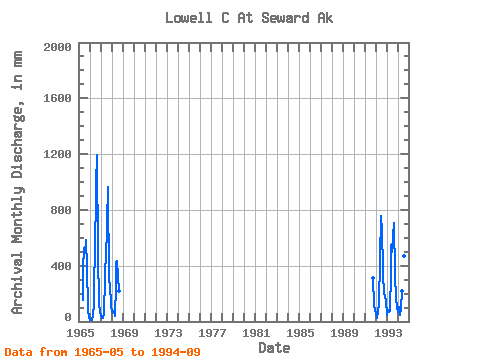
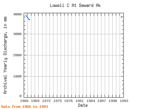
| Year | Jan | Feb | Mar | Apr | May | Jun | Jul | Aug | Sep | Oct | Nov | Dec | Annual | 1965 | 156.88 | 373.82 | 547.19 | 504.51 | 586.23 | 401.52 | 91.07 | 27.93 | 1966 | 12.14 | 19.66 | 13.16 | 45.41 | 127.96 | 314.55 | 473.29 | 1010.01 | 1194.13 | 497.27 | 133.84 | 68.09 | 3896.30 | 1967 | 48.84 | 24.02 | 25.49 | 62.03 | 313.06 | 394.51 | 442.64 | 727.50 | 966.63 | 296.86 | 265.12 | 118.99 | 3676.99 | 1968 | 69.64 | 70.55 | 73.55 | 42.31 | 261.62 | 422.50 | 450.11 | 336.34 | 219.73 | 1991 | 323.20 | 114.78 | 82.18 | 1992 | 61.37 | 22.63 | 67.03 | 132.34 | 456.09 | 758.90 | 728.98 | 720.95 | 326.05 | 220.16 | 171.23 | 156.39 | 3800.98 | 1993 | 45.60 | 77.94 | 74.01 | 77.45 | 355.89 | 546.24 | 512.68 | 635.80 | 706.69 | 351.40 | 158.09 | 105.59 | 3638.07 | 1994 | 73.93 | 95.28 | 49.02 | 88.97 | 222.74 | 584.60 | 767.87 | 486.92 | 421.57 |
|---|
 Return to R-Arctic Net Home Page