|
|
|||||||||||||||||
| Point ID: 9191 | Downloads | Plots | Site Data | Code: 15226000 |
|
|
|||||||||||||||||
| Download | |
|---|---|
| Site Descriptor Information | Site Time Series Data |
| Link to all available data | |
| View: | Time Series | All |
| Units: | m3/s |
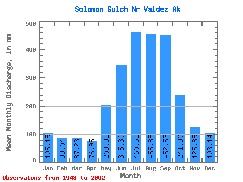
| Statistic | Jan | Feb | Mar | Apr | May | Jun | Jul | Aug | Sep | Oct | Nov | Dec | Annual |
|---|---|---|---|---|---|---|---|---|---|---|---|---|---|
| Mean | 105.19 | 89.81 | 87.21 | 76.93 | 203.31 | 345.32 | 460.49 | 455.76 | 452.51 | 241.88 | 125.88 | 103.11 | 2760.39 |
| Standard Deviation | 62.24 | 56.13 | 59.89 | 48.56 | 74.40 | 144.98 | 143.79 | 119.18 | 185.74 | 105.54 | 48.59 | 58.24 | 453.31 |
| Min | 2.08 | 4.84 | 7.56 | 9.46 | 54.34 | 208.63 | 263.81 | 226.49 | 181.76 | 71.37 | 31.18 | 5.93 | 2008.90 |
| Max | 205.34 | 176.71 | 178.29 | 152.79 | 333.55 | 783.47 | 764.38 | 686.81 | 825.46 | 460.51 | 201.34 | 172.43 | 3585.39 |
| Coefficient of Variation | 0.59 | 0.62 | 0.69 | 0.63 | 0.37 | 0.42 | 0.31 | 0.26 | 0.41 | 0.44 | 0.39 | 0.56 | 0.16 |
 Return to R-Arctic Net Home Page