|
|
|||||||||||||||||
| Point ID: 9191 | Downloads | Plots | Site Data | Code: 15226000 |
|
|
|||||||||||||||||
| Download | |
|---|---|
| Site Descriptor Information | Site Time Series Data |
| Link to all available data | |
| View: | Time Series | All |
| Units: | mm |
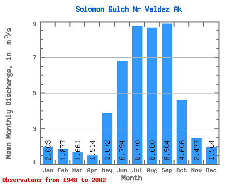
| Statistic | Jan | Feb | Mar | Apr | May | Jun | Jul | Aug | Sep | Oct | Nov | Dec | Annual |
|---|---|---|---|---|---|---|---|---|---|---|---|---|---|
| Mean | 2.00 | 1.88 | 1.66 | 1.51 | 3.87 | 6.79 | 8.77 | 8.68 | 8.90 | 4.61 | 2.48 | 1.96 | 4.46 |
| Standard Deviation | 1.19 | 1.17 | 1.14 | 0.95 | 1.42 | 2.85 | 2.74 | 2.27 | 3.66 | 2.01 | 0.96 | 1.11 | 0.73 |
| Min | 0.04 | 0.10 | 0.14 | 0.19 | 1.03 | 4.11 | 5.02 | 4.31 | 3.58 | 1.36 | 0.61 | 0.11 | 3.25 |
| Max | 3.91 | 3.69 | 3.40 | 3.01 | 6.35 | 15.41 | 14.56 | 13.08 | 16.24 | 8.77 | 3.96 | 3.28 | 5.79 |
| Coefficient of Variation | 0.59 | 0.62 | 0.69 | 0.63 | 0.37 | 0.42 | 0.31 | 0.26 | 0.41 | 0.44 | 0.39 | 0.56 | 0.16 |
 Return to R-Arctic Net Home Page