|
|
|||||||||||||||||
| Point ID: 9191 | Downloads | Plots | Site Data | Code: 15226000 |
|
|
|||||||||||||||||
| Download | |
|---|---|
| Site Descriptor Information | Site Time Series Data |
| Link to all available data | |
|
|
| View: | Statistics | Time Series |
| Units: | m3/s |
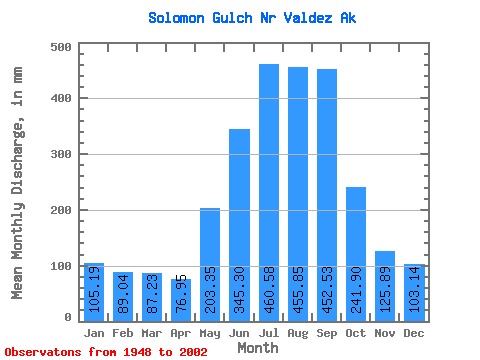
| Statistic | Jan | Feb | Mar | Apr | May | Jun | Jul | Aug | Sep | Oct | Nov | Dec | Annual |
|---|---|---|---|---|---|---|---|---|---|---|---|---|---|
| Mean | 105.19 | 89.81 | 87.21 | 76.93 | 203.31 | 345.32 | 460.49 | 455.76 | 452.51 | 241.88 | 125.88 | 103.11 | 2760.39 |
| Standard Deviation | 62.24 | 56.13 | 59.89 | 48.56 | 74.40 | 144.98 | 143.79 | 119.18 | 185.74 | 105.54 | 48.59 | 58.24 | 453.31 |
| Min | 2.08 | 4.84 | 7.56 | 9.46 | 54.34 | 208.63 | 263.81 | 226.49 | 181.76 | 71.37 | 31.18 | 5.93 | 2008.90 |
| Max | 205.34 | 176.71 | 178.29 | 152.79 | 333.55 | 783.47 | 764.38 | 686.81 | 825.46 | 460.51 | 201.34 | 172.43 | 3585.39 |
| Coefficient of Variation | 0.59 | 0.62 | 0.69 | 0.63 | 0.37 | 0.42 | 0.31 | 0.26 | 0.41 | 0.44 | 0.39 | 0.56 | 0.16 |
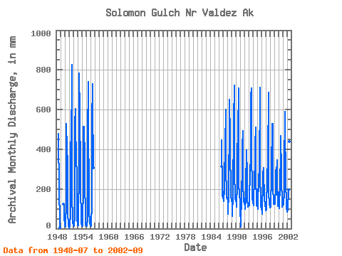
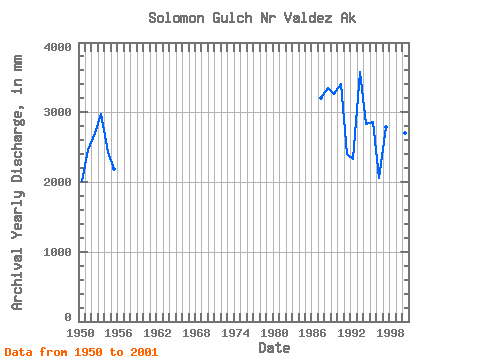
| Year | Jan | Feb | Mar | Apr | May | Jun | Jul | Aug | Sep | Oct | Nov | Dec | Annual | 1948 | 493.80 | 406.17 | 262.65 | 206.92 | 35.40 | 5.93 | 1949 | 129.06 | 120.55 | 53.00 | 1950 | 23.50 | 15.72 | 13.00 | 9.46 | 147.44 | 529.03 | 412.52 | 377.69 | 367.13 | 71.37 | 31.18 | 14.94 | 2008.90 | 1951 | 2.08 | 4.84 | 10.70 | 14.38 | 79.67 | 375.43 | 514.91 | 378.30 | 825.46 | 111.53 | 106.80 | 30.83 | 2454.45 | 1952 | 20.79 | 14.88 | 14.15 | 12.52 | 66.87 | 526.78 | 623.29 | 433.89 | 315.22 | 451.69 | 188.09 | 44.63 | 2699.59 | 1953 | 26.52 | 15.68 | 16.54 | 26.32 | 333.55 | 783.47 | 607.07 | 514.18 | 380.51 | 212.87 | 50.38 | 24.87 | 2980.22 | 1954 | 16.20 | 16.52 | 11.46 | 15.64 | 243.66 | 514.41 | 412.52 | 529.82 | 351.92 | 205.72 | 105.87 | 17.75 | 2431.48 | 1955 | 17.85 | 14.88 | 14.10 | 11.70 | 54.34 | 461.25 | 764.38 | 536.15 | 181.76 | 83.50 | 39.48 | 25.66 | 2189.57 | 1956 | 31.08 | 16.41 | 11.92 | 19.41 | 134.45 | 533.78 | 753.78 | 657.70 | 305.20 | 1986 | 312.11 | 460.51 | 166.03 | 172.43 | 1987 | 158.05 | 176.71 | 178.29 | 138.88 | 207.55 | 221.68 | 460.83 | 424.64 | 601.47 | 312.11 | 176.05 | 160.44 | 3213.02 | 1988 | 155.35 | 147.90 | 143.17 | 74.79 | 193.73 | 208.63 | 554.71 | 673.81 | 455.69 | 393.60 | 201.34 | 166.97 | 3354.11 | 1989 | 147.74 | 131.13 | 153.68 | 62.42 | 183.71 | 218.13 | 490.07 | 558.22 | 720.74 | 285.63 | 162.67 | 152.24 | 3258.34 | 1990 | 151.91 | 139.73 | 129.02 | 109.54 | 240.17 | 328.94 | 547.10 | 496.25 | 708.40 | 243.61 | 164.30 | 159.53 | 3413.33 | 1991 | 158.10 | 104.46 | 7.56 | 37.66 | 160.03 | 220.09 | 263.81 | 424.97 | 493.44 | 245.63 | 132.93 | 158.05 | 2402.39 | 1992 | 156.46 | 117.26 | 120.77 | 98.77 | 152.97 | 228.49 | 389.57 | 408.09 | 272.15 | 162.55 | 111.00 | 127.39 | 2337.81 | 1993 | 127.97 | 108.38 | 119.86 | 128.19 | 317.00 | 279.00 | 376.97 | 686.81 | 707.68 | 405.79 | 189.59 | 149.75 | 3585.39 | 1994 | 142.31 | 122.61 | 120.34 | 134.99 | 263.28 | 268.25 | 322.46 | 433.70 | 510.76 | 268.41 | 131.92 | 121.30 | 2835.26 | 1995 | 205.34 | 109.54 | 103.99 | 99.25 | 284.44 | 254.54 | 274.52 | 283.33 | 712.48 | 255.42 | 166.80 | 111.76 | 2860.77 | 1996 | 109.60 | 105.29 | 77.51 | 72.44 | 260.31 | 275.12 | 315.53 | 226.49 | 218.66 | 144.47 | 132.35 | 121.40 | 2055.09 | 1997 | 108.83 | 87.14 | 98.23 | 105.02 | 267.69 | 285.67 | 324.56 | 361.18 | 686.92 | 195.12 | 121.09 | 151.28 | 2790.09 | 1998 | 112.43 | 100.10 | 114.68 | 152.79 | 234.35 | 296.70 | 545.05 | 506.65 | 528.99 | 223.52 | 124.10 | 138.43 | 3068.13 | 1999 | 139.82 | 120.77 | 134.92 | 124.82 | 219.06 | 281.12 | 318.68 | 249.65 | 344.15 | 227.88 | 111.96 | 150.81 | 2419.85 | 2000 | 177.28 | 174.07 | 153.01 | 103.05 | 236.71 | 262.69 | 344.57 | 485.11 | 284.19 | 272.82 | 112.40 | 112.67 | 2711.36 | 2001 | 126.15 | 141.81 | 159.48 | 118.54 | 191.65 | 297.05 | 609.27 | 431.44 | 355.76 | 235.31 | 138.88 | 102.64 | 2899.09 | 2002 | 104.13 | 79.83 | 99.53 | 98.77 | 203.51 | 292.05 | 331.65 | 454.08 | 409.45 |
|---|
 Return to R-Arctic Net Home Page