|
|
|||||||||||||||||
| Point ID: 9188 | Downloads | Plots | Site Data | Code: 15087690 |
|
|
|||||||||||||||||
| Download | |
|---|---|
| Site Descriptor Information | Site Time Series Data |
| Link to all available data | |
| View: | Time Series | All |
| Units: | m3/s |
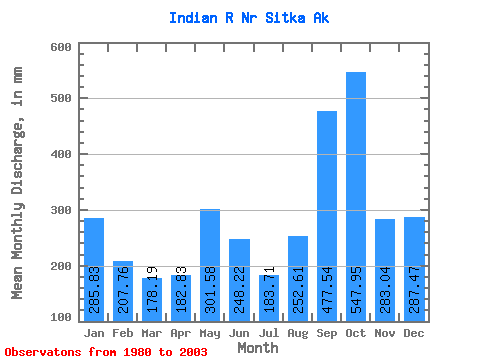
| Statistic | Jan | Feb | Mar | Apr | May | Jun | Jul | Aug | Sep | Oct | Nov | Dec | Annual |
|---|---|---|---|---|---|---|---|---|---|---|---|---|---|
| Mean | 285.76 | 209.55 | 178.18 | 182.86 | 301.50 | 248.17 | 183.64 | 252.62 | 477.57 | 547.88 | 283.07 | 287.47 | 3512.86 |
| Standard Deviation | 113.91 | 114.26 | 81.44 | 63.82 | 108.09 | 96.01 | 71.41 | 148.22 | 184.22 | 140.40 | 132.60 | 159.03 | 481.79 |
| Min | 134.08 | 65.27 | 57.51 | 81.33 | 107.38 | 80.78 | 59.59 | 86.74 | 147.91 | 300.08 | 103.66 | 62.93 | 2872.01 |
| Max | 532.57 | 405.27 | 353.02 | 309.94 | 484.11 | 464.56 | 322.69 | 688.58 | 826.98 | 849.17 | 611.55 | 598.30 | 4394.20 |
| Coefficient of Variation | 0.40 | 0.55 | 0.46 | 0.35 | 0.36 | 0.39 | 0.39 | 0.59 | 0.39 | 0.26 | 0.47 | 0.55 | 0.14 |
 Return to R-Arctic Net Home Page