|
|
|||||||||||||||||
| Point ID: 9188 | Downloads | Plots | Site Data | Code: 15087690 |
|
|
|||||||||||||||||
| Download | |
|---|---|
| Site Descriptor Information | Site Time Series Data |
| Link to all available data | |
| View: | Time Series | All |
| Units: | mm |
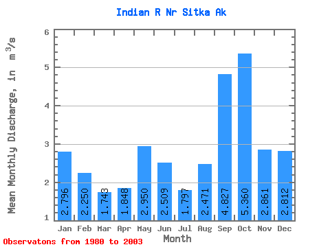
| Statistic | Jan | Feb | Mar | Apr | May | Jun | Jul | Aug | Sep | Oct | Nov | Dec | Annual |
|---|---|---|---|---|---|---|---|---|---|---|---|---|---|
| Mean | 2.80 | 2.25 | 1.74 | 1.85 | 2.95 | 2.51 | 1.80 | 2.47 | 4.83 | 5.36 | 2.86 | 2.81 | 2.92 |
| Standard Deviation | 1.11 | 1.23 | 0.80 | 0.65 | 1.06 | 0.97 | 0.70 | 1.45 | 1.86 | 1.37 | 1.34 | 1.56 | 0.40 |
| Min | 1.31 | 0.70 | 0.56 | 0.82 | 1.05 | 0.82 | 0.58 | 0.85 | 1.50 | 2.94 | 1.05 | 0.62 | 2.38 |
| Max | 5.21 | 4.35 | 3.45 | 3.13 | 4.74 | 4.70 | 3.16 | 6.74 | 8.36 | 8.31 | 6.18 | 5.85 | 3.65 |
| Coefficient of Variation | 0.40 | 0.55 | 0.46 | 0.35 | 0.36 | 0.39 | 0.39 | 0.59 | 0.39 | 0.26 | 0.47 | 0.55 | 0.14 |
 Return to R-Arctic Net Home Page