|
|
|||||||||||||||||
| Point ID: 9188 | Downloads | Plots | Site Data | Code: 15087690 |
|
|
|||||||||||||||||
| Download | |
|---|---|
| Site Descriptor Information | Site Time Series Data |
| Link to all available data | |
|
|
| View: | Statistics | Time Series |
| Units: | m3/s |
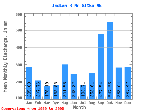
| Statistic | Jan | Feb | Mar | Apr | May | Jun | Jul | Aug | Sep | Oct | Nov | Dec | Annual |
|---|---|---|---|---|---|---|---|---|---|---|---|---|---|
| Mean | 285.76 | 209.55 | 178.18 | 182.86 | 301.50 | 248.17 | 183.64 | 252.62 | 477.57 | 547.88 | 283.07 | 287.47 | 3512.86 |
| Standard Deviation | 113.91 | 114.26 | 81.44 | 63.82 | 108.09 | 96.01 | 71.41 | 148.22 | 184.22 | 140.40 | 132.60 | 159.03 | 481.79 |
| Min | 134.08 | 65.27 | 57.51 | 81.33 | 107.38 | 80.78 | 59.59 | 86.74 | 147.91 | 300.08 | 103.66 | 62.93 | 2872.01 |
| Max | 532.57 | 405.27 | 353.02 | 309.94 | 484.11 | 464.56 | 322.69 | 688.58 | 826.98 | 849.17 | 611.55 | 598.30 | 4394.20 |
| Coefficient of Variation | 0.40 | 0.55 | 0.46 | 0.35 | 0.36 | 0.39 | 0.39 | 0.59 | 0.39 | 0.26 | 0.47 | 0.55 | 0.14 |
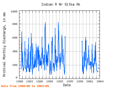
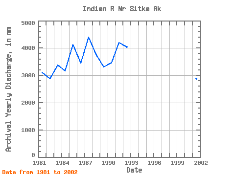
| Year | Jan | Feb | Mar | Apr | May | Jun | Jul | Aug | Sep | Oct | Nov | Dec | Annual | 1980 | 143.25 | 366.43 | 710.33 | 299.28 | 175.81 | 1981 | 401.94 | 213.71 | 139.96 | 109.64 | 154.25 | 150.80 | 245.01 | 274.02 | 546.83 | 352.47 | 380.25 | 146.87 | 3119.03 | 1982 | 195.60 | 94.75 | 97.20 | 136.15 | 446.85 | 284.24 | 166.61 | 167.04 | 400.42 | 614.28 | 173.87 | 105.22 | 2872.01 | 1983 | 210.27 | 95.60 | 101.31 | 309.94 | 484.11 | 193.20 | 143.00 | 688.58 | 537.78 | 455.62 | 119.81 | 62.93 | 3388.18 | 1984 | 532.57 | 339.92 | 286.45 | 144.10 | 177.30 | 213.84 | 167.63 | 367.12 | 163.42 | 300.08 | 172.75 | 299.06 | 3162.67 | 1985 | 527.15 | 388.33 | 172.82 | 176.77 | 421.28 | 464.56 | 322.69 | 220.63 | 409.38 | 494.09 | 112.34 | 427.06 | 4138.03 | 1986 | 222.41 | 175.94 | 353.02 | 188.26 | 217.64 | 304.51 | 200.03 | 268.15 | 147.91 | 630.42 | 298.72 | 467.87 | 3460.02 | 1987 | 377.19 | 217.47 | 213.54 | 268.48 | 341.73 | 349.23 | 124.60 | 154.80 | 734.34 | 849.17 | 391.18 | 373.65 | 4394.20 | 1988 | 134.08 | 397.84 | 257.41 | 196.57 | 401.66 | 207.12 | 186.44 | 278.69 | 471.19 | 529.48 | 419.47 | 274.22 | 3767.17 | 1989 | 253.31 | 96.35 | 57.51 | 167.52 | 274.03 | 161.36 | 64.91 | 86.74 | 548.23 | 388.31 | 611.55 | 598.30 | 3306.54 | 1990 | 204.75 | 112.17 | 232.48 | 223.74 | 219.69 | 195.91 | 105.28 | 233.61 | 740.97 | 556.66 | 207.96 | 437.71 | 3464.08 | 1991 | 250.22 | 312.97 | 118.57 | 214.50 | 332.29 | 286.68 | 244.09 | 317.64 | 826.98 | 684.10 | 361.57 | 248.07 | 4207.46 | 1992 | 369.37 | 223.69 | 193.74 | 137.36 | 387.38 | 237.92 | 253.29 | 338.92 | 584.19 | 661.78 | 429.56 | 225.85 | 4037.28 | 1993 | 285.80 | 405.27 | 238.93 | 201.42 | 208.96 | 80.78 | 59.59 | 123.33 | 612.67 | 1998 | 564.41 | 103.66 | 160.50 | 1999 | 321.37 | 65.27 | 79.64 | 286.21 | 398.59 | 388.18 | 201.97 | 172.53 | 366.42 | 628.36 | 262.39 | 584.19 | 3736.53 | 2000 | 193.26 | 107.85 | 169.92 | 213.38 | 285.50 | 304.33 | 256.35 | 210.08 | 482.03 | 372.25 | 280.51 | 209.69 | 3081.95 | 2001 | 201.77 | 187.05 | 260.12 | 138.20 | 255.07 | 242.70 | 226.20 | 92.43 | 352.88 | 521.27 | 221.31 | 183.09 | 2879.49 | 2002 | 231.65 | 211.63 | 110.55 | 81.33 | 313.33 | 280.51 | 222.01 | 502.22 | 254.65 | 548.80 | 249.05 | 194.29 | 3191.15 | 2003 | 230.99 | 126.02 | 124.09 | 97.87 | 107.38 | 121.20 | 115.91 | 159.93 | 527.04 |
|---|
 Return to R-Arctic Net Home Page