|
|
|||||||||||||||||
| Point ID: 9146 | Downloads | Plots | Site Data | Code: 15102000 |
|
|
|||||||||||||||||
| Download | |
|---|---|
| Site Descriptor Information | Site Time Series Data |
| Link to all available data | |
| View: | Time Series | All |
| Units: | m3/s |
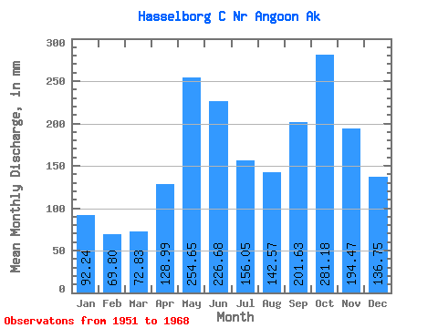
| Statistic | Jan | Feb | Mar | Apr | May | Jun | Jul | Aug | Sep | Oct | Nov | Dec | Annual |
|---|---|---|---|---|---|---|---|---|---|---|---|---|---|
| Mean | 92.23 | 70.40 | 72.81 | 129.00 | 254.61 | 226.67 | 156.03 | 142.54 | 201.62 | 281.14 | 194.47 | 136.73 | 1976.58 |
| Standard Deviation | 45.95 | 38.37 | 45.53 | 50.73 | 68.63 | 55.36 | 45.25 | 65.08 | 89.25 | 80.29 | 60.27 | 73.01 | 230.75 |
| Min | 15.71 | 24.69 | 27.12 | 27.72 | 143.09 | 125.42 | 64.58 | 49.88 | 63.80 | 141.85 | 64.46 | 22.70 | 1577.24 |
| Max | 180.36 | 148.89 | 224.51 | 193.36 | 365.37 | 351.06 | 230.09 | 243.51 | 387.18 | 396.30 | 283.93 | 268.71 | 2358.76 |
| Coefficient of Variation | 0.50 | 0.55 | 0.62 | 0.39 | 0.27 | 0.24 | 0.29 | 0.46 | 0.44 | 0.29 | 0.31 | 0.53 | 0.12 |
 Return to R-Arctic Net Home Page