|
|
|||||||||||||||||
| Point ID: 9146 | Downloads | Plots | Site Data | Code: 15102000 |
|
|
|||||||||||||||||
| Download | |
|---|---|
| Site Descriptor Information | Site Time Series Data |
| Link to all available data | |
|
|
| View: | Statistics | Time Series |
| Units: | m3/s |
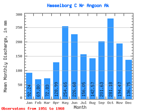
| Statistic | Jan | Feb | Mar | Apr | May | Jun | Jul | Aug | Sep | Oct | Nov | Dec | Annual |
|---|---|---|---|---|---|---|---|---|---|---|---|---|---|
| Mean | 92.23 | 70.40 | 72.81 | 129.00 | 254.61 | 226.67 | 156.03 | 142.54 | 201.62 | 281.14 | 194.47 | 136.73 | 1976.58 |
| Standard Deviation | 45.95 | 38.37 | 45.53 | 50.73 | 68.63 | 55.36 | 45.25 | 65.08 | 89.25 | 80.29 | 60.27 | 73.01 | 230.75 |
| Min | 15.71 | 24.69 | 27.12 | 27.72 | 143.09 | 125.42 | 64.58 | 49.88 | 63.80 | 141.85 | 64.46 | 22.70 | 1577.24 |
| Max | 180.36 | 148.89 | 224.51 | 193.36 | 365.37 | 351.06 | 230.09 | 243.51 | 387.18 | 396.30 | 283.93 | 268.71 | 2358.76 |
| Coefficient of Variation | 0.50 | 0.55 | 0.62 | 0.39 | 0.27 | 0.24 | 0.29 | 0.46 | 0.44 | 0.29 | 0.31 | 0.53 | 0.12 |
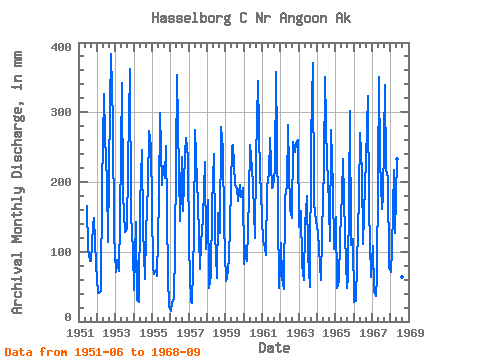
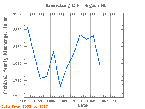
| Year | Jan | Feb | Mar | Apr | May | Jun | Jul | Aug | Sep | Oct | Nov | Dec | Annual | 1951 | 165.75 | 107.93 | 89.89 | 87.33 | 141.85 | 148.86 | 85.90 | 1952 | 41.66 | 37.96 | 44.78 | 192.78 | 336.69 | 265.34 | 206.11 | 118.45 | 309.62 | 396.30 | 283.93 | 129.60 | 2358.76 | 1953 | 73.75 | 83.23 | 74.65 | 148.12 | 354.01 | 182.18 | 132.81 | 137.23 | 223.15 | 374.16 | 153.31 | 103.73 | 2034.77 | 1954 | 46.45 | 134.56 | 31.25 | 27.72 | 173.89 | 245.36 | 136.60 | 63.68 | 128.58 | 202.50 | 272.82 | 257.99 | 1725.41 | 1955 | 80.69 | 63.74 | 75.64 | 65.53 | 183.12 | 299.22 | 202.10 | 230.49 | 205.30 | 260.41 | 64.46 | 22.70 | 1748.75 | 1956 | 15.71 | 24.69 | 32.63 | 105.79 | 365.37 | 212.70 | 148.85 | 243.51 | 158.00 | 248.20 | 263.63 | 244.17 | 2052.76 | 1957 | 110.05 | 26.09 | 27.12 | 126.11 | 284.03 | 199.78 | 176.07 | 78.22 | 111.94 | 153.59 | 228.79 | 106.70 | 1623.54 | 1958 | 180.36 | 45.15 | 67.64 | 165.09 | 247.76 | 125.42 | 64.58 | 160.85 | 126.51 | 287.66 | 247.36 | 143.55 | 1854.54 | 1959 | 60.56 | 57.67 | 93.85 | 139.00 | 259.12 | 253.46 | 202.45 | 196.87 | 172.40 | 201.90 | 179.17 | 197.18 | 2007.31 | 1960 | 84.64 | 102.30 | 89.56 | 178.03 | 262.01 | 220.63 | 200.94 | 123.86 | 232.69 | 355.91 | 208.26 | 191.25 | 2246.91 | 1961 | 117.19 | 105.67 | 98.54 | 193.36 | 220.61 | 263.31 | 198.44 | 198.87 | 218.07 | 369.57 | 158.77 | 48.92 | 2189.32 | 1962 | 116.58 | 59.06 | 47.48 | 176.62 | 200.84 | 282.01 | 164.80 | 153.66 | 256.71 | 251.53 | 256.59 | 268.71 | 2231.86 | 1963 | 139.31 | 148.89 | 84.43 | 58.98 | 143.09 | 180.49 | 100.06 | 51.34 | 261.17 | 382.62 | 169.29 | 149.58 | 1871.85 | 1964 | 132.84 | 98.05 | 60.82 | 127.00 | 228.16 | 351.06 | 230.09 | 215.38 | 116.03 | 283.53 | 191.37 | 107.19 | 2138.12 | 1965 | 154.17 | 44.66 | 59.63 | 119.47 | 188.13 | 233.04 | 126.97 | 49.88 | 63.80 | 311.98 | 110.21 | 122.26 | 1577.24 | 1966 | 29.27 | 28.01 | 87.38 | 178.32 | 279.75 | 214.24 | 114.57 | 201.71 | 231.28 | 333.60 | 161.77 | 65.64 | 1919.30 | 1967 | 112.05 | 40.76 | 37.97 | 63.77 | 361.45 | 231.26 | 167.03 | 185.73 | 339.43 | 224.11 | 207.47 | 79.28 | 2044.89 | 1968 | 72.63 | 96.25 | 224.51 | 127.24 | 240.35 | 154.89 | 128.18 | 66.14 | 387.18 |
|---|
 Return to R-Arctic Net Home Page