|
|
|||||||||||||||||
| Point ID: 9146 | Downloads | Plots | Site Data | Code: 15102000 |
|
|
|||||||||||||||||
| Download | |
|---|---|
| Site Descriptor Information | Site Time Series Data |
| Link to all available data | |
| View: | Time Series | All |
| Units: | mm |
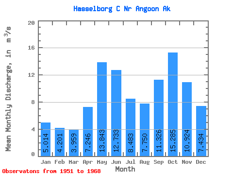
| Statistic | Jan | Feb | Mar | Apr | May | Jun | Jul | Aug | Sep | Oct | Nov | Dec | Annual |
|---|---|---|---|---|---|---|---|---|---|---|---|---|---|
| Mean | 5.01 | 4.20 | 3.96 | 7.25 | 13.84 | 12.73 | 8.48 | 7.75 | 11.33 | 15.29 | 10.92 | 7.43 | 9.12 |
| Standard Deviation | 2.50 | 2.29 | 2.48 | 2.85 | 3.73 | 3.11 | 2.46 | 3.54 | 5.01 | 4.37 | 3.38 | 3.97 | 1.06 |
| Min | 0.85 | 1.47 | 1.47 | 1.56 | 7.78 | 7.04 | 3.51 | 2.71 | 3.58 | 7.71 | 3.62 | 1.23 | 7.28 |
| Max | 9.81 | 8.88 | 12.21 | 10.86 | 19.86 | 19.72 | 12.51 | 13.24 | 21.75 | 21.55 | 15.95 | 14.61 | 10.88 |
| Coefficient of Variation | 0.50 | 0.55 | 0.62 | 0.39 | 0.27 | 0.24 | 0.29 | 0.46 | 0.44 | 0.29 | 0.31 | 0.53 | 0.12 |
 Return to R-Arctic Net Home Page