|
|
|||||||||||||||||
| Point ID: 9140 | Downloads | Plots | Site Data | Code: 15292700 |
|
|
|||||||||||||||||
| Download | |
|---|---|
| Site Descriptor Information | Site Time Series Data |
| Link to all available data | |
| View: | Time Series | All |
| Units: | m3/s |
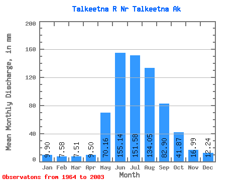
| Statistic | Jan | Feb | Mar | Apr | May | Jun | Jul | Aug | Sep | Oct | Nov | Dec | Annual |
|---|---|---|---|---|---|---|---|---|---|---|---|---|---|
| Mean | 9.90 | 7.65 | 7.51 | 9.50 | 70.15 | 155.13 | 151.56 | 134.03 | 82.90 | 41.86 | 16.99 | 12.24 | 695.55 |
| Standard Deviation | 1.78 | 1.52 | 1.90 | 3.80 | 30.09 | 45.15 | 29.50 | 34.50 | 33.90 | 22.59 | 5.07 | 2.53 | 106.32 |
| Min | 6.70 | 5.37 | 4.18 | 5.62 | 31.46 | 73.93 | 103.86 | 55.55 | 29.39 | 20.88 | 9.54 | 7.90 | 382.82 |
| Max | 14.62 | 13.23 | 15.52 | 27.14 | 168.80 | 270.31 | 226.07 | 245.97 | 171.61 | 146.71 | 34.07 | 16.45 | 900.89 |
| Coefficient of Variation | 0.18 | 0.20 | 0.25 | 0.40 | 0.43 | 0.29 | 0.20 | 0.26 | 0.41 | 0.54 | 0.30 | 0.21 | 0.15 |
 Return to R-Arctic Net Home Page