|
|
|||||||||||||||||
| Point ID: 9140 | Downloads | Plots | Site Data | Code: 15292700 |
|
|
|||||||||||||||||
| Download | |
|---|---|
| Site Descriptor Information | Site Time Series Data |
| Link to all available data | |
|
|
| View: | Statistics | Time Series |
| Units: | m3/s |
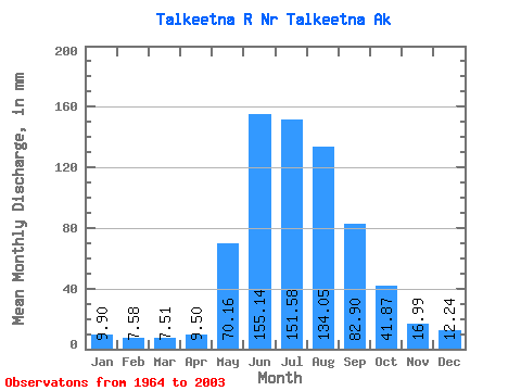
| Statistic | Jan | Feb | Mar | Apr | May | Jun | Jul | Aug | Sep | Oct | Nov | Dec | Annual |
|---|---|---|---|---|---|---|---|---|---|---|---|---|---|
| Mean | 9.90 | 7.65 | 7.51 | 9.50 | 70.15 | 155.13 | 151.56 | 134.03 | 82.90 | 41.86 | 16.99 | 12.24 | 695.55 |
| Standard Deviation | 1.78 | 1.52 | 1.90 | 3.80 | 30.09 | 45.15 | 29.50 | 34.50 | 33.90 | 22.59 | 5.07 | 2.53 | 106.32 |
| Min | 6.70 | 5.37 | 4.18 | 5.62 | 31.46 | 73.93 | 103.86 | 55.55 | 29.39 | 20.88 | 9.54 | 7.90 | 382.82 |
| Max | 14.62 | 13.23 | 15.52 | 27.14 | 168.80 | 270.31 | 226.07 | 245.97 | 171.61 | 146.71 | 34.07 | 16.45 | 900.89 |
| Coefficient of Variation | 0.18 | 0.20 | 0.25 | 0.40 | 0.43 | 0.29 | 0.20 | 0.26 | 0.41 | 0.54 | 0.30 | 0.21 | 0.15 |
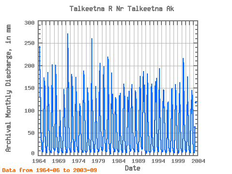
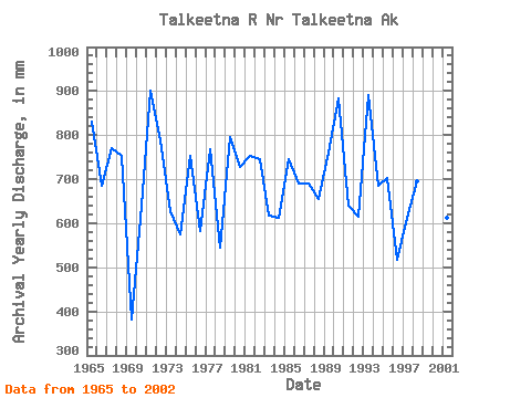
| Year | Jan | Feb | Mar | Apr | May | Jun | Jul | Aug | Sep | Oct | Nov | Dec | Annual | 1964 | 226.12 | 134.32 | 114.85 | 50.51 | 42.61 | 20.76 | 15.05 | 1965 | 9.85 | 7.73 | 7.39 | 7.68 | 47.52 | 146.88 | 166.59 | 152.51 | 140.46 | 60.70 | 19.33 | 11.98 | 775.63 | 1966 | 9.73 | 6.56 | 5.41 | 5.58 | 32.96 | 171.73 | 138.10 | 146.72 | 71.09 | 32.66 | 11.87 | 10.26 | 640.25 | 1967 | 8.71 | 6.81 | 6.44 | 5.65 | 56.25 | 122.94 | 172.36 | 193.75 | 92.29 | 27.75 | 16.59 | 13.50 | 718.48 | 1968 | 11.64 | 9.68 | 10.17 | 13.01 | 120.92 | 186.72 | 153.65 | 103.22 | 54.55 | 22.40 | 10.94 | 7.61 | 701.44 | 1969 | 6.28 | 5.00 | 5.20 | 6.87 | 52.92 | 68.94 | 96.84 | 51.80 | 27.40 | 19.83 | 10.13 | 8.03 | 356.97 | 1970 | 6.90 | 5.71 | 6.02 | 7.21 | 54.02 | 105.63 | 141.23 | 119.71 | 79.34 | 38.53 | 21.80 | 15.09 | 597.94 | 1971 | 9.29 | 5.71 | 5.50 | 6.66 | 29.34 | 252.06 | 160.92 | 229.35 | 79.30 | 36.01 | 17.34 | 11.56 | 840.05 | 1972 | 9.95 | 7.82 | 6.58 | 6.87 | 48.10 | 168.19 | 164.51 | 130.99 | 115.30 | 49.66 | 18.18 | 12.16 | 735.87 | 1973 | 10.24 | 8.14 | 7.85 | 7.63 | 52.79 | 161.69 | 105.00 | 135.78 | 51.12 | 24.72 | 12.71 | 10.19 | 585.73 | 1974 | 8.82 | 6.97 | 6.60 | 7.08 | 77.66 | 106.31 | 106.07 | 105.38 | 63.06 | 26.91 | 13.26 | 10.59 | 535.91 | 1975 | 9.49 | 7.30 | 6.95 | 6.91 | 55.86 | 174.49 | 165.15 | 116.09 | 105.38 | 39.45 | 10.24 | 7.63 | 702.67 | 1976 | 7.17 | 5.98 | 6.42 | 8.12 | 47.05 | 140.10 | 123.46 | 110.64 | 42.43 | 25.40 | 14.63 | 14.63 | 543.50 | 1977 | 9.58 | 6.85 | 6.92 | 7.25 | 58.05 | 242.01 | 127.80 | 109.49 | 78.94 | 44.70 | 14.84 | 11.76 | 717.15 | 1978 | 10.20 | 7.17 | 6.64 | 7.07 | 40.35 | 98.35 | 147.62 | 95.76 | 47.22 | 22.70 | 15.07 | 12.75 | 507.89 | 1979 | 10.42 | 8.13 | 7.90 | 9.39 | 106.55 | 159.05 | 197.47 | 113.18 | 53.47 | 46.22 | 22.75 | 11.87 | 741.77 | 1980 | 11.05 | 9.24 | 9.57 | 13.75 | 65.97 | 150.70 | 190.08 | 98.81 | 71.51 | 35.57 | 15.14 | 9.81 | 678.07 | 1981 | 8.91 | 6.66 | 7.46 | 8.89 | 61.95 | 87.24 | 210.80 | 200.78 | 58.04 | 32.09 | 16.36 | 9.69 | 702.36 | 1982 | 8.89 | 5.82 | 3.90 | 6.36 | 45.31 | 171.37 | 151.46 | 99.45 | 126.50 | 45.84 | 16.46 | 14.80 | 694.68 | 1983 | 11.44 | 7.23 | 7.74 | 8.85 | 62.24 | 119.32 | 119.05 | 120.40 | 52.22 | 44.86 | 14.52 | 10.68 | 575.21 | 1984 | 9.44 | 7.80 | 8.21 | 7.35 | 54.82 | 123.49 | 121.68 | 133.53 | 50.52 | 30.05 | 15.34 | 12.27 | 571.35 | 1985 | 9.80 | 6.82 | 6.81 | 6.91 | 57.10 | 137.67 | 152.36 | 139.29 | 111.54 | 45.37 | 13.26 | 10.71 | 694.57 | 1986 | 9.31 | 7.36 | 5.48 | 5.24 | 34.72 | 82.20 | 125.15 | 109.86 | 91.20 | 136.81 | 26.37 | 15.34 | 644.78 | 1987 | 11.38 | 9.18 | 9.02 | 11.83 | 69.24 | 128.58 | 151.39 | 135.03 | 70.94 | 23.57 | 15.05 | 13.19 | 645.03 | 1988 | 11.19 | 8.81 | 8.29 | 7.88 | 72.10 | 133.83 | 132.34 | 109.06 | 67.82 | 34.25 | 15.00 | 13.19 | 610.92 | 1989 | 9.53 | 7.19 | 7.52 | 7.94 | 49.62 | 141.19 | 114.30 | 169.81 | 113.19 | 56.11 | 20.57 | 14.36 | 708.48 | 1990 | 13.63 | 12.34 | 14.47 | 25.31 | 157.40 | 173.52 | 115.60 | 119.08 | 145.69 | 30.18 | 10.86 | 9.20 | 825.21 | 1991 | 8.34 | 5.07 | 4.65 | 9.48 | 84.30 | 169.19 | 136.40 | 87.01 | 53.98 | 25.97 | 8.89 | 7.39 | 598.27 | 1992 | 6.76 | 5.98 | 7.13 | 9.13 | 38.30 | 137.29 | 152.85 | 116.65 | 52.85 | 21.51 | 16.06 | 13.15 | 574.91 | 1993 | 9.79 | 6.88 | 6.86 | 12.01 | 139.36 | 153.20 | 125.95 | 114.73 | 160.02 | 70.46 | 21.98 | 13.24 | 831.48 | 1994 | 10.81 | 8.41 | 7.26 | 13.95 | 94.65 | 180.05 | 118.22 | 120.74 | 39.90 | 24.80 | 12.89 | 10.57 | 639.58 | 1995 | 8.71 | 6.83 | 7.39 | 8.32 | 92.17 | 135.87 | 139.76 | 102.35 | 101.00 | 34.23 | 14.41 | 7.36 | 655.72 | 1996 | 6.25 | 5.48 | 6.39 | 9.92 | 64.57 | 81.81 | 110.33 | 114.53 | 47.68 | 19.47 | 10.70 | 9.55 | 483.38 | 1997 | 8.43 | 6.79 | 6.54 | 8.06 | 51.89 | 100.71 | 140.15 | 143.17 | 71.27 | 21.75 | 9.51 | 7.79 | 572.58 | 1998 | 6.58 | 5.56 | 5.65 | 8.74 | 54.55 | 138.27 | 152.11 | 126.40 | 83.82 | 41.84 | 16.44 | 11.94 | 648.81 | 1999 | 9.11 | 6.05 | 5.12 | 6.51 | 50.18 | 128.30 | 129.61 | 156.19 | 58.77 | 37.44 | 16.77 | 11.41 | 611.86 | 2000 | 8.87 | 7.00 | 6.84 | 8.72 | 61.44 | 201.10 | 189.29 | 86.67 | 82.53 | 43.78 | 16.59 | 11.89 | 722.46 | 2001 | 9.77 | 7.45 | 7.19 | 8.12 | 49.55 | 163.34 | 109.54 | 114.31 | 54.89 | 27.70 | 12.49 | 9.09 | 571.66 | 2002 | 7.37 | 6.14 | 5.89 | 5.81 | 98.53 | 86.62 | 98.62 | 138.83 | 115.18 | 78.54 | 31.77 | 13.95 | 683.31 | 2003 | 6.35 | 6.39 | 5.71 | 13.57 | 60.78 | 130.27 | 164.80 | 113.14 | 58.98 |
|---|
 Return to R-Arctic Net Home Page