|
|
|||||||||||||||||
| Point ID: 9140 | Downloads | Plots | Site Data | Code: 15292700 |
|
|
|||||||||||||||||
| Download | |
|---|---|
| Site Descriptor Information | Site Time Series Data |
| Link to all available data | |
| View: | Time Series | All |
| Units: | mm |
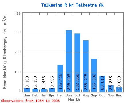
| Statistic | Jan | Feb | Mar | Apr | May | Jun | Jul | Aug | Sep | Oct | Nov | Dec | Annual |
|---|---|---|---|---|---|---|---|---|---|---|---|---|---|
| Mean | 19.11 | 16.20 | 14.49 | 18.95 | 135.42 | 309.41 | 292.57 | 258.73 | 165.33 | 80.81 | 33.88 | 23.63 | 113.93 |
| Standard Deviation | 3.44 | 3.22 | 3.67 | 7.58 | 58.08 | 90.05 | 56.95 | 66.59 | 67.62 | 43.60 | 10.12 | 4.88 | 17.42 |
| Min | 12.93 | 11.37 | 8.07 | 11.20 | 60.73 | 147.45 | 200.48 | 107.24 | 58.61 | 40.31 | 19.02 | 15.24 | 62.71 |
| Max | 28.22 | 28.03 | 29.96 | 54.13 | 325.85 | 539.12 | 436.40 | 474.81 | 342.27 | 283.21 | 67.95 | 31.76 | 147.57 |
| Coefficient of Variation | 0.18 | 0.20 | 0.25 | 0.40 | 0.43 | 0.29 | 0.20 | 0.26 | 0.41 | 0.54 | 0.30 | 0.21 | 0.15 |
 Return to R-Arctic Net Home Page